Category: Trail Guide

  • Mountain Biking Brevard NC: Mile of Trails in Pisgah and DuPont Forest

    Mountain Biking Brevard NC: Mile of Trails in Pisgah and DuPont Forest

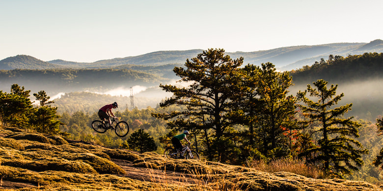
    600+ Trails, World-Class Pisgah & DuPont Riding, and Everything You Need for the Ultimate North Carolina Mountain Biking Adventure

    Brevard, North Carolina stands as the “Cycling Capital of the South,” offering over 600 trails across 400+ miles of world-class singletrack within a 30-minute radius. This Western North Carolina mountain town delivers an unparalleled combination of technical Pisgah National Forest terrain, unique granite slickrock at DuPont State Forest, and a thriving community that welcomes riders from weekend warriors to World Cup professionals. Recent recovery from Hurricane Helene has reopened most trail systems, making Brevard once again accessible as one of North America’s top 10 mountain biking destinations.

    The area’s temperate rainforest climate enables year-round riding across two distinctly different trail ecosystems—from the brutal “Pisgah Gnar” featuring epic climbs and technical descents to DuPont’s more approachable granite domes and waterfall-lined trails. This comprehensive diversity, combined with a passionate local community and excellent infrastructure, creates a mountain biking experience that rivals western destinations while maintaining the welcoming character of a small mountain town.

    Trail systems that define world-class riding

    Pisgah National Forest represents the crown jewel of Southeastern mountain biking with over 500,000 acres containing hundreds of miles of trails. The Pisgah Ranger District alone features 648 documented trails, earning legendary status for its technical challenges and epic terrain. Black Mountain Trail (#127) stands as the area’s most iconic ride, a 12-20 mile journey losing 1,900 feet of elevation through extremely technical descents laden with rocks and drops. This classic Pisgah experience epitomizes the “old school” mountain biking that built the area’s reputation.

    DuPont State Recreational Forest offers a completely different experience across its 10,400 acres with nearly 100 miles of multi-use trails. The forest’s unique granite slickrock sections rival those found in Moab, providing rare East Coast riding on smooth granite domes with 360-degree valley views. Ridgeline Trail serves as DuPont’s signature experience—a fast, flowy downhill that showcases the forest’s more accessible character while still delivering thrills. Cedar Rock Trail and Big Rock Trail provide technical granite face descents that challenge advanced riders while remaining more forgiving than Pisgah’s brutal terrain.

    Panthertown Valley, known as the “Yosemite of the East,” adds backcountry wilderness riding to the mix across its 6,311 acres. This Nantahala National Forest gem offers 19 miles of intermediate-level trails winding through granite cliffs, mountain bogs, and past eight major waterfalls. The valley’s Blackrock Trail and Mac’s Gap Trail provide scenic riding that emphasizes natural beauty over technical challenge.

    Bent Creek Experimental Forest serves as the area’s most beginner-friendly option, offering 30 miles of well-maintained trails just 25 minutes from Brevard. The system’s Green’s Lick and Wolf Branch Loop provide perfect introduction to Pisgah-style riding without the intimidation factor of the main forest’s technical terrain.

    Difficulty progression from greenway to gnarly

    Beginner riders should start with Brevard’s excellent infrastructure before tackling mountain singletrack. The Brevard Greenway/Estatoe Trail provides 5.9-7.5 miles of paved riding through town, while Bracken Preserve offers 7 miles of natural surface trails within city limits that connect directly to Pisgah National Forest trails.

    Intermediate riders will find their sweet spot at DuPont State Forest, where most trails feature moderate obstacles and steeper terrain while maintaining ride-around options for challenging sections. The Daniel Ridge Trail in Pisgah provides excellent intermediate progression at 9+ miles with waterfalls and moderate technical features. Panthertown Valley’s network offers perfect intermediate riding with stunning scenery.

    Advanced and expert riders gravitate toward Pisgah’s legendary challenges. Bennett Gap delivers fast, technical descents with spectacular fall colors, while Avery Creek Trail tests riders with 3.2 miles of creek crossings and natural obstacles. Farlow Gap represents the ultimate expert challenge—a double black diamond descent considered the most technical in all of Pisgah.

    The beauty of Brevard lies in this seamless progression from beginner to expert terrain within a single destination, allowing riders to develop skills gradually while always having new challenges ahead.

    Local shops and services that fuel the community

    The Hub and Pisgah Tavern stands as Brevard’s unofficial mountain biking headquarters, uniquely combining a full-service bike shop with a beer garden featuring 8+ rotating craft taps and daily food trucks. Located directly at Pisgah National Forest’s entrance, The Hub serves as the natural gathering spot for pre-ride preparation and post-ride celebration.

    Earth Mountain Bicycle anchors downtown Brevard as the area’s Trek and Electra exclusive dealer, offering comprehensive rental services, full repairs, and specialized programs like Bikepacking 101 clinics. Their Trek Ride Club app provides 10-40% discounts and free lifetime tune-ups, making them particularly valuable for visitors planning multiple trips.

    Squatch Bikes & Brews caters to serious riders with premium brands including Yeti, Ibis, Cannondale, and Mondraker. Their expertise in high-end mountain bikes and customization serves advanced riders seeking cutting-edge equipment.

    Professional guide services add significant value for visitors wanting local expertise. The Bike Farm offers half-day ($160-260) and full-day ($260-360) private guided rides on their fleet of 2024 Yeti full-suspension bikes with Fox suspension and 12-speed drivetrains. Red Wolf Mountain Bike Tours provides custom experiences across both Pisgah and DuPont, licensed to operate in both forests.

    Pura Vida Adventures fills the crucial shuttle gap, offering $100 shuttles to premier trailheads like Bennett Gap and Cove Creek, enabling riders to access classic descents without epic climbs.

    Accommodations designed for mountain bikers

    Pilot Cove represents the ideal mountain biker accommodation, featuring efficiency to 2-bedroom cabins that border Pisgah National Forest with direct trail access. 85% of cabins allow pets, and the property offers secure bike storage with walking distance to bike shops and restaurants.

    The Bromfield Inn provides elegant bed-and-breakfast accommodations within walking distance of downtown Brevard. This historic 1926 property features 6 bedrooms with en suite baths and gourmet breakfast, perfect for riders wanting upscale comfort.

    Deerwoode Reserve offers nature preserve cabins ranging from studios to 4-bedroom lodges across 175 acres along the French Broad River. The dog-friendly property provides peaceful recovery space after challenging rides.

    Davidson River Campground places riders closest to trailheads for those preferring camping, though availability remains limited following Hurricane Helene damage—always check current conditions before booking.

    Seasonal rhythms that shape the riding experience

    Spring (April-May) delivers prime riding conditions with perfect 60-degree temperatures, spring wildflowers, and tacky dirt that provides ideal traction. Peak season officially begins in April when trails dry out from winter moisture.

    Summer (June-August) brings warmth, humidity, and frequent thunderstorms across 45 days annually, but also provides access to the area’s 250+ waterfalls and swimming holes for cooling relief. DuPont can get crowded on weekends, while Pisgah’s vast network disperses riders effectively.

    Fall (September-October) returns to prime conditions with comfortable temperatures and spectacular foliage that makes Brevard famous. Many locals consider autumn the absolute best time to visit, combining perfect weather with stunning scenery.

    Winter (November-February) enables year-round riding thanks to mild temperatures averaging 40-50°F, though occasional snow and freeze-thaw cycles require checking trail conditions. DuPont may close singletrack during wet periods, while Pisgah remains open with rider discretion advised.

    The area’s temperate rainforest climate produces 90+ inches of annual precipitation, creating lush, green landscapes year-round while requiring responsible riding practices during wet conditions.

    Community and events that create lasting connections

    Pisgah Area SORBA (PAS) serves as the backbone of Brevard’s mountain biking community, maintaining over 200 miles of singletrack through completely volunteer efforts. This nonprofit organization represents the gold standard for trail advocacy and stewardship.

    Blue Ridge Bicycle Club boasts over 1,000 members and offers group rides virtually every day from March through September. Their program spans all skill levels from social 12 mph rides to advanced 20+ mph club rides covering 40+ challenging miles.

    The Pisgah Stage Race stands as the area’s crown jewel event, offering 3-day and 5-day formats covering 140 miles with 20,000+ feet of elevation gain. As part of the East Coast Grand Slam, this race attracts elite riders from around the world while maintaining accessible amateur categories.

    PMBAR (Pisgah Mountain Bike Adventure Race) represents “the absolute pinnacle of MTB Adventure racing,” requiring teams of two to navigate 50-80 miles with 9,000-15,000 feet of climbing over 7-14 hours using only map and compass.

    The WNC Flyer draws 1,000+ riders annually for Blue Ridge Bicycle Club’s signature event, featuring four route options and a post-ride party at Oskar Blues Brewery that exemplifies the area’s celebration culture.

    What makes Brevard irreplaceably unique

    DuPont’s granite slickrock riding represents a geological anomaly, offering rare East Coast experiences typically found only in desert Southwest destinations like Moab. Trails like Cedar Rock and Big Rock provide smooth granite dome riding with 360-degree valley views impossible to find elsewhere east of the Mississippi.

    The combination of two distinctly different trail ecosystems within 30 minutes sets Brevard apart from any other destination. Riders can experience brutal “Pisgah Gnar” technical challenges in the morning and flowy granite features in the afternoon—diversity unmatched anywhere in North America.

    Brevard earned recognition as the only East Coast destination in Singletracks.com’s “Top 10 Mountain Bike Destinations in North America,” with experts describing it as “head-and-shoulders above every other potential destination on the East Coast.”

    The area’s professional-amateur integration creates an inspiring environment where World Cup veterans ride alongside weekend warriors, fostering a welcoming culture that encourages progression while maintaining accessibility.

    The “Land of Waterfalls” designation adds unique character with 250+ waterfalls providing swimming holes, scenic vistas, and cooling opportunities integrated directly into riding experiences—features simply unavailable in most mountain biking destinations.

    Practical information for planning your visit

    Current access remains mostly free across trail systems, though proposed changes may introduce $5/day or $30 annual passes for certain Pisgah areas including Bent Creek and Mills River systems. DuPont State Forest maintains free admission with parking available at multiple access points including Guion Farm and Lake Imaging areas.

    Hurricane Helene recovery continues following September 2024 damage, but Pisgah Ranger District has reopened with most popular trails clear and rideable. DuPont remains partially open with some closures, while Panthertown Valley and Bracken Preserve operate normally. Always check current conditions through Pisgah Area SORBA website or local bike shops before departing.

    E-bikes face strict restrictions—completely prohibited on all DuPont trails and non-motorized Pisgah trails. Trail etiquette emphasizes multi-use courtesy with proper yielding to hikers and equestrians on bi-directional trails.

    Transportation options include Asheville Regional Airport (19 miles, 27 minutes via I-26 and US-280) with rental cars and shuttle services available. Airport shuttles cost approximately $125 through services like Asheville Airport Shuttle.

    Limited cell service throughout most trail areas requires satellite communication devices for solo riders and careful trip planning with emergency contacts. Weather changes rapidly in the mountains, making layered clothing and preparation essential.

    Recent developments shaping the future

    Hurricane Helene recovery efforts have accelerated trail improvements and infrastructure rebuilding across the region. While causing initial disruption, the rebuilding process has enabled upgrades to bridges, drainage, and access roads that will benefit riders for years to come.

    Great American Outdoors Act (GAOA) funding supports ongoing improvements at area recreation facilities, while local organizations like SORBA continue expanding and maintaining trail networks through dedicated volunteer efforts.

    The proposed fee structure for certain Pisgah areas reflects growing popularity and need for sustainable funding, though implementation timelines remain under public review.

    Brevard’s recognition as a world-class destination continues growing, with industry professionals and elite riders increasingly choosing the area as their home base, further cementing its status as the Southeast’s premier mountain biking destination.

    Summing It Up

    Brevard, North Carolina delivers an unmatched mountain biking experience that combines world-class terrain diversity, passionate community, and year-round accessibility in ways that simply don’t exist elsewhere on the East Coast. From beginners discovering the joy of singletrack on Bent Creek’s gentle trails to experts testing themselves against Pisgah’s legendary technical challenges, every rider finds their perfect match within this compact mountain town’s extensive trail networks.

    The area’s unique combination of granite slickrock experiences, temperate rainforest riding, waterfall integration, and welcoming community creates lasting memories that draw riders back repeatedly. Recent hurricane recovery has only strengthened the community’s commitment to maintaining and improving the trail systems that make Brevard special.

    Whether planning a weekend getaway or an extended mountain biking pilgrimage, Brevard offers the infrastructure, terrain, and culture to create the trip of a lifetime while leaving riders already planning their return to the Cycling Capital of the South.

  • Occoneechee Mountain State Park: North Carolina’s Hidden Gem for Outdoor Enthusiasts

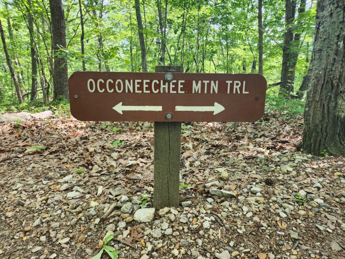
    Greetings adventurers, and welcome to my comprehensive guide to the wonder that is Occoneechee Mountain State Park! Nestled in the heart of North Carolina, this hidden gem offers a unique blend of natural beauty, rich history, and endless exploration opportunities.

    You might be wondering, what’s so special about this park? Well, let me tell you, it’s not just another green patch on the map. Occoneechee Mountain State Park holds a unique significance to both the local community and the delicate ecology of the region. It’s a treasure trove of biodiversity, bursting with a variety of flora and fauna that never fail to capture the heart of any nature lover. And its history? Just as enchanting. The park’s roots stretch deep into the past, bearing tales of Native American heritage and early settlers that add layers of cultural richness to this already spectacular landscape.

    As someone who has personally hiked every trail, marveled at every Mountain Laurel, and maybe even lost a boot in the mud here, I’m thrilled to be your guide through this stunning park. I’ll be sharing everything from practical tips on how to get here, where to park, and when to visit, to my personal favorite trails and picnic spots.

    So grab your hiking boots, fill up your water bottle, and let’s dive into the wonders of Occoneechee Mountain State Park. Whether you’re a seasoned hiker, a bird-watching enthusiast, or simply looking for a peaceful spot to enjoy the great outdoors with your dog, I promise, this park has something truly special in store for you. Let’s get started, shall we?

    Planning Your Visit to Occoneechee Mountain State Park

    So, you’re all set to explore the wonders of Occoneechee Mountain State Park? Excellent choice, my friend! But before we embark on this adventure, let’s talk logistics – because a smooth journey is half the fun, right?

    Directions and Diverse Transportation Options:

    Whether you’re coming from the bustling city of Raleigh, the charming town of Chapel Hill, or anywhere else in the glorious state of North Carolina, getting to Occoneechee Mountain State Park is a breeze. The park is nestled just off Interstate 85, a straight shot for those road-tripping it.

    If you’re using your trusty GPS, just type in “Occoneechee Mountain State Park” and let the satellites guide you. But for old-school map lovers, fret not – just head towards Hillsborough and follow the signs to the park.

    For those relying on public transportation, check out the Triangle Transit Authority for bus schedules that pass through Hillsborough. From there, it’s just a short taxi or Uber ride to the park.

    Parking Facilities, Fees, and Other Logistical Details:

    One thing I love about Occoneechee is that parking is a cinch. There’s a spacious parking lot at the park entrance – and guess what? Parking is absolutely free, which is always a bonus!

    Do remember that the park operates from 8 am to 6 pm in the winter months, and extends its hours to 8 am to 9 pm from March to November. Plan accordingly to make the most of your visit.

    Best Times to Visit and Seasonal Considerations:

    Every season paints Occoneechee in a different palette of colors, making it a year-round destination. But if you ask me (and many locals will agree), spring and fall are exceptionally beautiful. In spring, the park bursts into a riot of colors with blooming wildflowers, while fall transforms the landscape into a stunning canvas of oranges and reds.

    Keep in mind that North Carolina summers can get hot, so if you’re visiting in the summer months, make sure to bring plenty of water and sun protection. Winters are relatively mild, but always check the weather forecast for any unexpected changes.

    Now that we’ve covered the basics, let’s dive into the heart of the park – its facilities, amenities, and, of course, the trails. Ready to discover what Occoneechee Mountain State Park has in store for you? Let’s go!

    Facilities and Amenities within the Park

    Occoneechee Mountain State Park is more than just a hiking destination. It’s a well-equipped haven for nature lovers. From the Eno River State Park Office bursting with information to picnic spots with picture-perfect views, you’ll find the facilities to make your visit as enjoyable as it can be.

    Detailed Information about the Visitor Center:

    Occoneechee Mountain State Natural Area, located in North Carolina, does not have a dedicated visitor center. However, the park is managed by Eno River State Park, which provides valuable information and educational materials for visitors. Instead of a visitor center, individuals are encouraged to visit the office at Eno River State Park for assistance and educational resources which is located about 10 miles East of Occoneechee Mountain.

    At the office, you will find knowledgeable park staff who are eager to answer any questions you may have about Occooneechee Mountain or Eno River State Park. They can provide you with maps, brochures, and other materials that offer insights into the park’s history, wildlife, geology, and recreational opportunities.

    The office at Eno River State Park is an excellent starting point for your visit. You can gather valuable information about Occooneechee Mountain’s trails, points of interest, and safety guidelines. The staff can also provide recommendations based on your interests and help you plan a memorable experience in the park.

    While you won’t find traditional exhibits or audiovisual presentations at Occooneechee Mountain itself, the educational resources available at the office will still give you a deeper understanding of the park’s natural beauty and significance.

    As things are always changing it is recommended to visit the official website of Eno River State Park or contact the park office directly.

    Location and Features of Picnic Areas and Shelters:

    For those of you who, like me, love a good picnic, Occoneechee Mountain State Park doesn’t disappoint. Scattered around the park, you’ll find several picnic areas with tables and grills. My personal favorite is the spot near the Overlook; it’s like dining with a view. Do remember, though, that these areas are available on a first-come, first-serve basis.

    Availability and Location of Restrooms and Water Stations:

    Nobody likes to think about restrooms until they need one, right? You’ll find clean and well-maintained pit toilets at the park’s entrance, near the main parking lot. And when it comes to water, there are water stations located near the main Office as well as running water toilets. Just a tip – always carry a reusable water bottle to stay hydrated during your hike.

    Details about Camping Options:

    While the park itself may not offer camping facilities, your spirit for overnight adventure needn’t be dampened. You can find a host of camping options just outside its borders. Notably, Camping at Fews Ford presents an excellent choice, offering backpacking-only tent sites and group tent sites. As an added benefit, firewood is provided free to campers, availability permitting.

    Another viable option is Camping at Cole Mill, where you can find more tent sites dedicated solely to backpacking. Here too, campers can access firewood at no additional cost, subject to availability.

    Accessibility Information for Visitors with Special Needs:

    Ensuring everyone can enjoy the beauty of Occoneechee Mountain State Park is a priority. The park offers several wheelchair-friendly facilities, including accessible restrooms and picnic areas. Do note that due to the natural terrain, not all trails are wheelchair accessible, but the park staff will be happy to guide you to the most suitable areas.

    Now that we’ve got the basics down, it’s time for the real fun – hitting the trails! Ready to lace up those hiking boots and venture into the great outdoors? Let’s go!

    Exploring the Trails

    Alright, fellow wanderers, this is where the rubber meets the dirt! The trails at Occoneechee Mountain State Park are where the magic truly happens. With a variety of paths winding through lush forests, around the lake, and up to the mountain’s peak, you’re in for a real treat.

    Overview of the Trail System:

    Occoneechee boasts a diverse trail system, with something for every level of hiker. The park’s trails cover over 3 miles of beautiful terrain, each path offering a unique glimpse into the park’s natural beauty. From leisurely strolls to heart-pumping climbs, there’s a trail for everyone here.

    Detailed Breakdown of Difficulty Levels, Trail Lengths, and Elevations:

    Whether you’re a seasoned hiker or a beginner, Occoneechee has you covered. The main trail, the Occoneechee Mountain Loop, is a moderate 2.2-mile trail that offers a little bit of everything – steep inclines, gentle descents, and even a peaceful stroll along the Eno River. For a challenging trek, the Overlook trail takes you to the park’s highest point, while the family-friendly Chestnut Oak Trail offers a gentle, flat path perfect for little ones or those preferring a more leisurely pace.

    Clear Directions to Trailhead Locations and Access Points:

    All trails start from the main parking area. Clear signage points you to the beginning of each trail, and maps available at the kiosk provide details about access points along the routes. Don’t hesitate to ask park staff for any specific directions – they’re always eager to help!

    Tailored Recommendations for Trails Based on Interests, Abilities, and Time Constraints:

    If you’re short on time, I highly recommend the Chestnut Oak Trail. It’s a quick, 1-mile loop with some gorgeous views. For birdwatchers, the quiet, less-traveled Occoneechee Mountain Loop offers some fantastic spotting opportunities. And for the best views in the park? Head for the Overlook trail. The climb might leave you a bit breathless, but the stunning vistas at the top are well worth it!

    Key Points of Interest Along the Trails, Including Scenic Viewpoints, Unique Flora, and Fauna:

    As you trek, keep your eyes peeled for the wonders scattered along the trails. Marvel at the giant tulip poplars, the tallest trees in the park, found along the Mountain Loop. Or gaze across the quarry and Eno River from the overlook. And of course, don’t miss the impressive Occoneechee quartzite outcrop near the summit – it’s a sight to behold!

    Scenic Viewpoints

    • Occoneechee Mountain Summit: As the highest point in Orange County at 867 feet, the summit overlook provides views of the surrounding landscape. An ideal spot for bird watching or appreciating nature’s serenity.
    • River overlooks and fishing on the Eno River: There are a few tranquil spot perfect for river gazing or fishing. The river’s picturesque course through the lush landscape is particularly stunning at sunrise and sunset.
    • Quarry Viewpoint: Once a working stone quarry, this area now offers unique views of the sheer rock faces and the pond formed at its base.
    • Fishing in the Ponds: The park’s tranquil ponds offer excellent opportunities for fishing. Whether you’re an experienced angler or a novice, you’ll enjoy the serene environment and the chance to catch a variety of fish species.
    • Panther’s Den: Not an overlook in the traditional sense, this deep crevice in the side of the mountain provides a unique perspective on the park’s geology.

    Safety Guidelines, Trail Etiquette, and Emergency Procedures:

    Remember, safety first! Always stay on marked trails, keep a safe distance from any wildlife you encounter, and carry plenty of water. Follow the ‘Leave No Trace’ principles – leave only footprints and take only memories. If you need assistance, contact a park ranger immediately. They’re there to ensure your visit is safe and enjoyable.

    Wildlife and Natural Wonders

    Now that we’ve covered the trails, let’s talk about the stars of the show at Occoneechee Mountain State Park – the wildlife and natural features that truly make this park a paradise for nature enthusiasts. From the smallest insects to the grandest geological formations, there’s a world of wonders waiting to be discovered.

    Detailed Introduction to the Flora and Fauna Found in the Park:

    Occoneechee Mountain State Park is a living, breathing testament to the richness of North Carolina’s natural biodiversity. The park is home to a wide variety of trees, including mighty oaks, beautiful dogwoods, and towering pines. In the spring, the trails are lined with blooming wildflowers, adding a splash of color to your hike.

    As for the fauna, well, let’s just say you’ll want to keep your binoculars handy! Deer, raccoons, and squirrels are common sights along the trails. Birdwatchers will have a field day spotting everything from cardinals and blue jays to hawks and owls. And let’s not forget the smaller inhabitants – the park is buzzing with butterflies, beetles, and all sorts of fascinating insects.

    Unique Flora

    • Rhododendron and Mountain Laurel: Blooming vibrantly in late spring and early summer, these flowering shrubs add a burst of color to the park.
    • Chestnut Oak Forest: This unique ecosystem houses various plant species, including several ferns and wildflowers.
    • Piedmont Alluvial Forest: Along the banks of the Eno River, this habitat hosts a range of moisture-loving plants and trees.
    • Pitch Pine: This hardy tree species thrives in the rocky soil of Occoneechee Mountain, representing the resilience of nature.
    • Rare Lichens and Mosses: The park’s diverse microhabitats support a variety of lichens and mosses, some of which are rare and hard to find elsewhere.

    Fauna

    • Brown Elfin Knob Moth: A unique sight in the park is the Brown Elfin Knob Moth. This species is known for its distinctive brown coloration and is particularly active in the park during certain months of the year, adding a touch of magic to the park’s vibrant ecosystem.
    • Bird Species: Home to over 100 species of birds, including the red-tailed hawk, great horned owl, and various woodpeckers.
    • Mammals: Sightings of white-tailed deer, foxes, bobcats, squirrels, and chipmunks are not uncommon.
    • Reptiles and Amphibians: The park is a habitat for several species of frogs, toads, salamanders, turtles, and snakes.
    • Butterflies and Insects: A variety of butterflies, beetles, dragonflies, and other insects add to the park’s biodiversity.
    • Occasional Beavers: If you’re extremely lucky, you might spot a beaver in the Eno River, a rare and delightful sight.

    Highlights of Unique Geological Formations and Landmarks:

    Occoneechee isn’t just a haven for wildlife; it’s also a showcase of fascinating geological formations. The park is named after Occoneechee Mountain, the highest point in Orange County. This isn’t your typical mountain, though – it’s actually a monadnock, an isolated hill or small mountain that rises abruptly from a gently sloping or virtually level surrounding plain.

    One of the highlights along the trails is the Occoneechee Quartzite outcrop near the summit, a testament to the geological forces that shaped the landscape millions of years ago. There’s also the Eno River that flows gracefully along the edge of the park, carving out a picturesque landscape as it meanders along.

    Tips for Birdwatching and Wildlife Viewing Opportunities, Including Best Locations and Times:

    For those of you with a keen interest in birdwatching, Occoneechee Mountain State Park is a true paradise. The park is a magnet for a diverse array of bird species. Early morning and late afternoon are often the best times for birdwatching, when the park’s feathered inhabitants are most active.

    The quieter, less-traveled parts of the Occoneechee Mountain Loop are particularly great for birdwatching. Remember to be patient and quiet, and you’ll be rewarded with some truly amazing sights. Similarly, for wildlife viewing, early morning and late evening tend to be the best times. Keep a safe distance and use binoculars for a close-up view.

    Interpretive Programs and Activities

    Sure, you can wander around Occoneechee Mountain State Park on your own – and have an amazing time doing so – but why not take advantage of the park’s excellent interpretive programs and activities? They’re designed to enrich your understanding of the park’s natural and cultural history, and they add an extra layer of fun and education to your visit.

    Exploring Guided Tours and Educational Programs:

    First things first: check out the Ranger-led tours. These guided walks offer a wealth of information about the park’s ecology, geology, and history. Plus, you’ll get to ask questions and interact directly with a knowledgeable park ranger. They usually occur on weekends, but you can check the schedule at the Visitor Center or on the park’s website.

    If you’re visiting with kids, keep an eye out for the Junior Ranger Program. It’s a fun and interactive way for the little ones to learn about the park and its inhabitants. They’ll even earn a badge and a certificate – talk about a cool souvenir!

    Nature Walks, Hikes, and More:

    If you’re keen on exploring the trails with a group, consider joining one of the organized nature walks or hikes. They often have a theme – like birdwatching, tree identification, or wildflower spotting – and are a great way to meet fellow nature lovers.

    Special Events and Festivals:

    Throughout the year, Occoneechee Mountain State Park hosts a range of special events and festivals. These can include nature photography workshops, wildlife tracking seminars, star-gazing nights, and even local music and arts festivals. Check the park’s event calendar for up-to-date information.

    Volunteer Opportunities:

    Fancy lending a hand to keep Occoneechee Mountain State Park in tip-top shape? The park often needs volunteers for tasks like trail maintenance, invasive plant removal, and assistance during special events. It’s a fantastic way to give back to the park and ensure future visitors can enjoy it just as much as you do.

    Whether you prefer to explore at your own pace or want to dive deeper with a guided tour, the interpretive programs and activities at Occoneechee Mountain State Park offer something for everyone. So, go ahead, immerse yourself in the park’s wonders, and make some unforgettable memories!

    Safety and Park Regulations

    As we approach the end of our guide, let’s talk about something of utmost importance – safety and park regulations. Occoneechee Mountain State Park is a place of natural beauty and tranquility, and we all have a role to play in keeping it that way. So, here’s what you need to know:

    General Safety Guidelines:

    Always stay on marked trails to protect both the environment and yourself. Remember to dress appropriately for the weather and wear sturdy, comfortable shoes. Carry plenty of water, especially during the warmer months, and don’t forget your sunscreen and bug spray. If you’re hiking alone, let someone know your plans and estimated return time.

    Park Rules and Regulations:

    Park rules are there for a reason – to ensure everyone can enjoy the park in a safe and respectful way. Here are some key rules: pets must be kept on a leash at all times, no littering (pack out what you pack in), no picking of plants or disturbing of wildlife, and no smoking or open fires, except in designated areas.

    Leave No Trace Principles:

    Leave No Trace is more than just a slogan; it’s a commitment to preserving nature for future generations. The seven principles are: plan ahead and prepare; travel and camp on durable surfaces; dispose of waste properly; leave what you find; minimize campfire impact; respect wildlife; and be considerate of other visitors.

    Weather Considerations:

    Weather can change quickly, especially in the mountains. Keep an eye on the forecast and be prepared for different conditions. If severe weather is predicted, it might be best to postpone your visit.

    And lastly, remember: safety is everyone’s responsibility. The park rangers are there to help, but it’s up to each of us to make sure we’re behaving responsibly and respecting the park and its rules. Let’s work together to keep Occoneechee Mountain State Park a safe and enjoyable place for all!

    Nearby Attractions and Accommodations

    If you’re planning to extend your visit to the area or simply want to explore beyond the boundaries of Occoneechee Mountain State Park, you’re in luck. The surrounding region boasts a variety of attractions and accommodations that make it a fantastic destination for a weekend getaway or a longer vacation.

    Other Parks and Natural Areas in the Vicinity:

    If you’re a true nature lover and want to expand your explorations, there are several other parks and natural areas nearby. Eno River State Park, just a short drive away, offers additional hiking trails and a chance to canoe or kayak on the river. A bit further afield, you’ll find Falls Lake State Recreation Area, a great spot for fishing and camping.

    Local Attractions and Points of Interest:

    For a change of pace, consider visiting some of the local attractions. The town of Hillsborough is rich in history, with several historic sites and museums to explore. Or, for a unique experience, check out the Botanical Gardens and Planetarium at the nearby University of North Carolina at Chapel Hill.

    Lodging Options and Dining Establishments:

    There are plenty of accommodation options nearby, ranging from charming bed and breakfasts in Hillsborough to larger hotels in Durham or Chapel Hill. For those who prefer to immerse themselves in nature, consider camping at Fews Ford or Cole Mill. Both locations offer backpacking-only tent sites, and firewood is provided free to campers as available.

    As for dining, you’ll find everything from quaint cafes to gourmet restaurants offering local North Carolina cuisine. Remember, exploring the wider area can enrich your visit and give you a broader understanding of the region’s history, culture, and natural beauty.

    Park Contact Information

    As we wrap up our guide, let’s cover some essential information. Knowing how to get in touch with the park staff can be extremely helpful, whether you need to report a problem, ask for directions, or just want more information.

    Park Office Hours and Contact Details:

    The park office at Occoneechee Mountain State Park is typically open from 8 a.m. to 5 p.m. daily, but hours can vary depending on the season. You can reach the office at (919) 383-1686. For more information, you can also visit the park’s official website.

    Emergency Contact Information:

    In case of an emergency, dial 911 immediately. Additionally, it’s a good idea to note down the non-emergency contact number for the local police department. Park rangers are also available to assist during park operating hours.

    Remember, don’t hesitate to reach out if you have any questions or concerns during your visit. The park staff are there to ensure your experience at Occoneechee Mountain State Park is as enjoyable and safe as possible.

    Conclusion

    We’ve covered quite a bit of ground in this guide – from the rich history and natural beauty of Occoneechee Mountain State Park, to the practicalities of planning your visit, and even some tips for exploring the surrounding area. But remember, no guide can fully capture the unique charm and wonder of this park. That’s something you’ll have to experience for yourself.

    Occoneechee Mountain State Park is a testament to North Carolina’s natural beauty, a place where you can step away from the hustle and bustle of everyday life and immerse yourself in the great outdoors. Whether you’re an avid hiker, a birdwatcher, a history buff, or just someone seeking a bit of peace and tranquility, this park has something to offer you.

    So, what are you waiting for? Lace up your hiking boots, grab your binoculars, and get ready to explore the trails, spot some wildlife, and soak in the incredible views. Don’t forget to respect the park rules and regulations, and always leave no trace.

    We hope this guide inspires you to experience Occoneechee Mountain State Park for yourself. Trust us, it’s a place you’ll want to return to time and time again. Enjoy your adventure!

  • Linville Gorge: A Hiker’s Haven in North Carolina

    Linville Gorge: A Hiker’s Haven in North Carolina

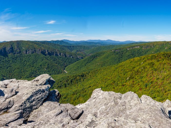
    Nestled within the heart of North Carolina’s Blue Ridge Mountains, Linville Gorge is a hiker’s paradise just waiting to be explored. This magnificent, wild canyon stretches over 12 miles long and is often referred to as the “Grand Canyon of the East.” With its rugged beauty, breathtaking views, and a diverse array of trails, Linville Gorge offers an unforgettable hiking experience for adventurers of all levels.

    How Hard is the Hike to Linville Falls?

    The hike to Linville Falls is relatively accessible for most hikers, offering various trails with different levels of difficulty to suit your preferences and abilities. The easiest and most popular route is the Linville Falls Trail, which is 1.6 miles round trip and considered moderate in difficulty. The trail features several overlooks, providing stunning views of the multi-tiered waterfall. For a more challenging experience, consider taking the Plunge Basin Trail, a 1-mile strenuous hike that descends into the gorge and offers an up-close view of the falls.

    What is the Most Beautiful Gorge in North Carolina?

    While beauty is subjective, many people consider Linville Gorge to be one of the most beautiful gorges in North Carolina, if not the most beautiful. Known as the “Grand Canyon of the East,” Linville Gorge boasts dramatic cliffs, lush forests, and cascading waterfalls that create a breathtaking and diverse landscape. The gorge’s rugged terrain and remote wilderness offer a true escape into nature, providing endless opportunities for adventure and tranquility.

    What is the Hardest Trail in Linville Gorge?

    The most challenging trail in Linville Gorge is arguably the Linville Gorge Trail, also known as the LGT or “The Gorge Trail.” This 11.5-mile trail traverses the base of the gorge and follows the Linville River. The trail is strenuous and technical, with frequent elevation changes, rocky terrain, and several challenging river crossings. Hikers should be well-prepared and experienced before attempting this trail, as it can take several days to complete and requires backcountry navigation skills.

    Is Linville Falls Worth Visiting?

    Absolutely! Linville Falls is not only one of the most famous and photographed waterfalls in North Carolina, but it is also a must-visit destination for nature lovers and outdoor enthusiasts. The falls’ unique, multi-tiered cascade and the surrounding Linville Gorge create a stunning and dramatic landscape that is well worth the effort of hiking to its multiple overlooks. The area offers a variety of trails for all skill levels, ensuring that visitors can find a route that suits their abilities and interests.

    But the Gorge is more than just a pretty place to hike; it’s also home to a unique ecosystem that needs our protection. As you trek through this stunning landscape, you’ll be walking among rare plant species and diverse wildlife, all of which contribute to the area’s delicate balance. It’s crucial that we, as visitors, do our part to respect and preserve the environment, ensuring that Linville Gorge remains a cherished treasure for generations to come.

    So lace up your hiking boots and get ready for an epic adventure as we explore the ins and outs of Linville Gorge, one of North Carolina’s most awe-inspiring natural wonders. In this informal, descriptive, and informative guide, we’ll cover everything you need to know about hiking in Linville Gorge, from trail highlights to practical advice for making your trip both enjoyable and eco-friendly. Let’s dive in!

    Getting to Linville Gorge

    Location and directions

    Linville Gorge, part of the Pisgah National Forest, is located in western North Carolina, approximately 70 miles northeast of Asheville. The main access point for hiking trails in the gorge is the Linville Gorge Information Cabin, where you can find trail maps and helpful information.

    To get there from Asheville, head east on I-40 and take exit 81 for US-221 N towards Linville Falls. Continue on US-221 N for about 29 miles, then turn right onto NC-183. In just under 4 miles, turn left onto Kistler Memorial Highway/NC-1238, and the Information Cabin will be on your left after about 2 miles.

    Nearby towns and facilities

    The towns closest to Linville Gorge are Marion, Morganton, and Boone. Marion and Morganton are located to the southeast, while Boone is situated to the northwest. All three towns offer accommodations, dining options, and grocery stores for stocking up on supplies before your hike.

    Best times to visit

    While Linville Gorge can be visited year-round, the most popular time to hike is during the spring and fall months, when temperatures are mild and the foliage is at its most vibrant. Spring brings a burst of wildflowers, while fall offers a colorful display of changing leaves. Summer can also be a great time to visit, but keep in mind that temperatures can be quite hot and humid, making hiking more strenuous. In the winter, snow and ice can make some trails inaccessible, so be sure to check trail conditions before venturing out during this season.

    Preparing for Your Hike

    Essential gear and clothing

    To ensure a safe and enjoyable hike in Linville Gorge, it’s crucial to pack the right gear. The following items are recommended for your hiking adventure, taking into account the terrain, weather conditions, and types of trails you may encounter:

    • Sturdy hiking boots: Opt for footwear with good ankle support and a grippy sole to navigate the rugged, uneven terrain of the gorge.
    • Weather-appropriate clothing: Dress in layers to adapt to changing temperatures, and pack rain gear for unexpected showers.
    • Navigation tools: Bring a map, compass, and/or GPS device to help you stay on course, as some trails may be less well-marked or maintained.
    • Hydration and nutrition: Carry plenty of water, especially during hot summer months, and pack high-energy snacks or a packed lunch to keep your energy levels up.
    • First-aid kit: Include basic first-aid supplies such as adhesive bandages, pain relievers, antiseptic wipes, and any personal medications you may require.
    • Emergency supplies: Pack a whistle, a signal mirror, and a lightweight emergency blanket in case you need to signal for help or spend an unplanned night in the wilderness.
    • Sun protection: Wear sunscreen, sunglasses, and a hat to protect yourself from the sun’s harmful rays, especially during summer hikes.
    • Insect repellent: Bring bug spray to ward off mosquitoes, ticks, and other insects that can be common in the gorge.
    • Trekking poles (optional): Consider using trekking poles to provide extra support and stability on steep or rocky trails.
    • Camera or smartphone: Capture the stunning landscapes and memorable moments of your Linville Gorge adventure.

    By packing these essential items, you’ll be well-equipped to tackle the challenges and enjoy the rewards of hiking in Linville Gorge, regardless of the trail you choose or the season in which you visit.

    Weather considerations

    Weather in Linville Gorge can be unpredictable, so it’s important to check the forecast before setting out on your hike. In addition to dressing in layers, be prepared for sudden changes in temperature, rain, or even snow at higher elevations during colder months. Start your hikes early in the day to avoid afternoon thunderstorms that are common in the summer months.

    Safety precautions and tips

    It’s important to note that Linville Gorge can be a challenging and sometimes dangerous destination. On average, at least one person per month is rescued from the gorge due to various reasons such as injuries, getting lost, or encountering unexpected hazards. To minimize the risk of accidents and ensure a safe hiking experience, consider the following tips:

    • Stay on marked trails: The terrain in the gorge can be challenging, so it’s crucial to stay on designated trails to avoid getting lost or injured.
    • Know your limits: Choose a trail that matches your experience and fitness level. Don’t hesitate to turn back if you feel uncomfortable or tired.
    • Be aware of wildlife: While encounters with dangerous wildlife are rare, it’s essential to know how to react if you encounter a bear, snake, or other wild animals.
    • Share your plans: Let someone know your hiking plans, including your intended route and expected return time, in case of an emergency.
    • Cell phone reception: Reception can be spotty in the gorge, so don’t rely solely on your phone for communication or navigation.
    • Hike with a buddy: Whenever possible, hike with a partner or a group. This not only makes the journey more enjoyable but also provides an extra level of safety in case of an emergency.
    • Know your route: Familiarize yourself with the trail you plan to hike and any potential hazards it may present. Be aware of the trail’s difficulty level and any technical sections that might require special skills or equipment.
    • Carry emergency supplies: In addition to your essential gear, pack a whistle, a signal mirror, and a lightweight emergency blanket. These items can be invaluable in case you need to signal for help or spend an unplanned night in the wilderness.
    • Stay alert: Pay close attention to your surroundings and be prepared for changing weather conditions, slippery terrain, or any other potential hazards that may arise during your hike.

    By keeping these safety tips in mind, you’ll be better prepared for your Linville Gorge adventure and significantly reduce the risk of accidents or needing rescue. Stay safe and enjoy the spectacular beauty of the gorge!

    Seasonal Considerations: Adapting to Linville Gorge’s Changing Weather

    Linville Gorge’s hiking experience can vary significantly depending on the season, with each offering its unique challenges and highlights. Being aware of these seasonal differences can help you plan and prepare for a safe and enjoyable hike in the gorge.

    Spring: The spring season brings colorful wildflowers and rushing waterfalls as the snow melts, but it can also come with unpredictable weather, including sudden rainstorms and temperature fluctuations. Be prepared for wet and muddy trails, and pack waterproof gear and extra layers to stay comfortable.

    Summer: Summer days can be hot and humid, with the potential for afternoon thunderstorms. Stay hydrated, wear sun protection, and consider starting your hike early in the morning to avoid the heat. Be especially cautious of slippery rocks near waterfalls and stream crossings.

    Fall: Autumn offers cooler temperatures and vibrant foliage, making it a popular time to hike in Linville Gorge. However, the trails can be crowded during peak leaf season, so plan your visit accordingly. Pack extra layers, as temperatures can drop quickly in the evenings.

    Winter: Winter brings snow, ice, and frigid temperatures, making some trails and access points impassable or challenging to navigate. If you choose to hike during this season, be prepared for winter conditions by packing appropriate gear, such as microspikes or snowshoes, and researching trail conditions before setting out.

    By understanding the seasonal variations in Linville Gorge, you can make informed decisions about when to visit and what to expect during your hiking adventure. Always be prepared for changing weather conditions, and adjust your plans as needed to stay safe and enjoy the best that each season has to offer.

    Exploring Linville Gorge’s Natural Beauty

    As you hike through Linville Gorge, you’ll be treated to a diverse array of natural wonders that showcase the beauty of this rugged landscape. From dramatic cliffs and lush forests to cascading waterfalls and panoramic views, there’s no shortage of breathtaking sights to discover.

    Marvel at the dramatic cliffs

    Linville Gorge’s sheer cliffs are one of its most striking features, providing awe-inspiring backdrops for photos and challenging terrain for rock climbers. As you hike along the rim, you’ll find numerous overlooks offering sweeping views of these towering rock faces and the gorge below. It’s important to remember that safety should be a top priority when exploring these areas, as the ledges can be dangerous if not approached with caution.

    When admiring the view or taking photos, always maintain a safe distance from the edge, and be aware of your surroundings. Uneven terrain, loose rocks, or slippery surfaces can pose hazards, especially if you’re not paying attention. If you’re hiking with children, be sure to keep a close eye on them and hold their hands near ledges.

    For rock climbers, proper preparation and adherence to safety guidelines are crucial. Be sure to use appropriate climbing gear, have a solid understanding of the route you plan to take, and only attempt climbs within your skill level. Additionally, it’s wise to climb with a partner or inform someone of your plans before embarking on a climbing adventure.

    By prioritizing safety and being cautious around the ledges in Linville Gorge, you can enjoy the spectacular views and thrilling adventures this park offers while minimizing risks and ensuring a memorable experience.

    Wander through lush forests


    The trails of Linville Gorge wind through dense forests filled with diverse flora, providing a rich and varied backdrop for your hike. As you navigate the gorge, you’ll encounter a lush mix of tree species, including tulip poplars, oaks, hickories, and pines, along with an understory of rhododendron, mountain laurel, and various ferns.

    Tulip poplars, the tallest hardwoods in the eastern United States, can be easily identified by their unique, tulip-shaped leaves and large, greenish-yellow flowers that bloom in late spring. Oaks are another prevalent species in the gorge, distinguished by their lobed leaves and the production of acorns. Hickories are known for their compound leaves and durable wood, which is often used for tool handles and furniture. Pines, with their needle-like leaves and distinct cones, provide year-round greenery to the forest landscape.

    As you hike, take time to appreciate the natural beauty around you, marvel at the towering canopy, and breathe in the fresh, earthy scents of the forest.

    Discover cascading waterfalls

    Linville Gorge is home to several enchanting waterfalls that invite hikers to pause and enjoy the soothing sounds of water tumbling over rocks. Don’t miss Linville Falls, a multi-tiered waterfall that’s easily accessible via a short trail and offers stunning views from multiple overlooks. In addition to Linville Falls, the gorge also features other beautiful cascades worth exploring, such as:

    • Duggers Creek Falls: This small, picturesque waterfall is located near the Linville Falls Visitor Center and is a short walk from the parking area. The gentle cascade is surrounded by lush vegetation, making it a perfect spot for a peaceful break.
    • Babel Tower Falls: For those seeking a more challenging adventure, the Babel Tower Trail leads to a striking waterfall that plunges down the rocky cliffs of Linville Gorge. The strenuous hike rewards visitors with an up-close view of the cascade and the opportunity to explore the base of the waterfall.
    • Cathedral Falls: Accessible via the Pinch-In Trail, Cathedral Falls is another hidden gem in Linville Gorge. The hike to this waterfall can be strenuous, but the dramatic cascade and the serene pool at its base are well worth the effort.

    As you hike through Linville Gorge, take the time to seek out these captivating waterfalls and immerse yourself in the natural beauty they offer. Each cascade provides a unique experience, making every waterfall visit a memorable part of your Linville Gorge adventure.

    Take in panoramic vistas

    Linville Gorge is home to several enchanting waterfalls that invite hikers to pause and enjoy the soothing sounds of water tumbling over rocks. Don’t miss Linville Falls, a multi-tiered waterfall that’s easily accessible via a short trail and offers stunning views from multiple overlooks. In addition to Linville Falls, the gorge also features other beautiful cascades worth exploring, such as:

    • Duggers Creek Falls: This small, picturesque waterfall is located near the Linville Falls Visitor Center and is a short walk from the parking area. The gentle cascade is surrounded by lush vegetation, making it a perfect spot for a peaceful break.
    • Babel Tower Falls: For those seeking a more challenging adventure, the Babel Tower Trail leads to a striking waterfall that plunges down the rocky cliffs of Linville Gorge. The strenuous hike rewards visitors with an up-close view of the cascade and the opportunity to explore the base of the waterfall.
    • Cathedral Falls: Accessible via the Pinch-In Trail, Cathedral Falls is another hidden gem in Linville Gorge. The hike to this waterfall can be strenuous, but the dramatic cascade and the serene pool at its base are well worth the effort.

    As you hike through Linville Gorge, take the time to seek out these captivating waterfalls and immerse yourself in the natural beauty they offer. Each cascade provides a unique experience, making every waterfall visit a memorable part of your Linville Gorge adventure.

    Wildlife Encounters: Meeting the Gorge’s Inhabitants

    While hiking through Linville Gorge, you’ll have the opportunity to spot a variety of wildlife species that call this rugged landscape home. From birds of prey soaring overhead to small mammals scurrying through the underbrush, the gorge’s diverse habitats support a wide range of creatures.

    Some common wildlife you might encounter include:

    • White-tailed deer
    • Black bears
    • Wild turkeys
    • Peregrine falcons
    • River otters
    • Eastern box turtles
    • Various songbirds

    When observing wildlife, it’s important to follow these guidelines to ensure both your safety and the well-being of the animals:

    • Keep a safe distance: Do not approach or attempt to touch wildlife. Use binoculars or a camera with a zoom lens to get a closer look without disturbing the animals.
    • Do not feed wildlife: Feeding animals can alter their natural behavior, making them more likely to approach humans and potentially become aggressive. Additionally, human food can be harmful to their health.
    • Stay quiet and move slowly: Avoid making loud noises or sudden movements that might startle or disturb wildlife.

    By respecting these guidelines, you can enjoy memorable encounters with Linville Gorge’s wildlife while ensuring their continued well-being in this beautiful and wild environment.

    As you explore the gorge, be sure to take in all the unique aspects of its natural beauty. This incredible destination offers endless opportunities for adventure, tranquility, and connection with nature.

    Top Trails to Explore

    Linville Gorge offers a variety of trails for hikers of all levels. Here are some of the top trails that you won’t want to miss:

    Babel Tower Trail: A Steep Challenge with Rewarding Views

    Length: 2.4 miles round trip
    Difficulty: Strenuous

    This steep, challenging hike takes you to the base of Babel Tower, an impressive rock formation with panoramic views of the gorge. The trail begins at the Babel Tower trailhead, where there is limited parking available. The hike starts with a steep descent through a dense forest before reaching the tower, where you can take in the breathtaking scenery and even go for a refreshing dip in the nearby Linville River. Along the way, you’ll find water sources like creeks and designated campsites for an overnight stay.

    Linville Falls Trail: Captivating Waterfalls and Scenic Vistas

    Length: 1.6 miles round trip
    Difficulty: Moderate

    Linville Falls is one of the most iconic sights in the gorge, and this moderate hike takes you to several viewpoints of the stunning cascades. The trail begins at the Linville Falls Visitor Center, where there is ample parking available. The trail meanders through lush forests and offers spectacular views of the falls and the surrounding cliffs. There are water sources along the trail, such as creeks and streams, and a few designated campsites near the Linville Falls area for those wishing to extend their adventure.

    Hawksbill Mountain Trail: A Must-See Panoramic Summit

    Length: 2 miles round trip
    Difficulty: Moderate

    Climbing to the summit of Hawksbill Mountain is a must-do for any Linville Gorge visitor. The trail begins at the Hawksbill Mountain trailhead, where there is limited parking available. This moderately challenging trail takes you through beautiful forests and meadows before reaching the summit, where you’ll be rewarded with 360-degree views of the gorge and surrounding mountains. There are no water sources along this trail, so be sure to bring enough water for your hike. Designated campsites can be found near the summit for those wishing to spend the night.

    Shortoff Mountain Trail: A Hike with Stunning Views and Secluded Camping

    Length: 9.8 miles round trip
    Difficulty: Moderate

    The hike to Shortoff Mountain begins at the Wolf Pit trailhead, where there is a small parking area. The trail follows the eastern rim of Linville Gorge, providing sweeping views of the canyon and surrounding peaks. Along the way, you’ll pass through a mix of forests and rocky outcrops. There are several designated camping spots on the mountain, making this an ideal overnight hike for those looking to get away from it all. However, water sources are scarce, so be prepared to carry enough water for your hike.

    The Pinch-In Trail: The Most Challenging Adventure in the Gorge

    Length: 4 miles round trip
    Difficulty: Strenuous

    For experienced hikers seeking a true challenge, the Pinch-In Trail is a must. This strenuous hike begins at the Kistler Memorial Highway trailhead, where there is limited parking available. The trail takes you from the rim of the gorge down to the Linville River, with steep climbs and rocky terrain throughout. Along the way, you’ll pass by towering cliffs, lush forests, and cascading waterfalls. You’ll find designated campsites along the river, but water sources are limited, so plan accordingly.

    Linville Gorge Grand Loop: A Comprehensive Adventure Through the Best of the Gorge

    Length: 22 miles round trip
    Difficulty: Strenuous

    For experienced hikers seeking an unforgettable, immersive experience, the Linville Gorge Grand Loop is the ultimate trail to tackle. This challenging 23-mile loop takes you through the heart of the gorge, combining the best of several trails, including the Linville Gorge Trail (LGT), the Jonas Ridge Trail, and the Mountains-to-Sea Trail (MST), making it the longest trail in the Linville Gorge Wilderness. You’ll encounter breathtaking views, dramatic cliffs, lush forests, and cascading waterfalls while traversing the gorge’s rim and floor. The Linville Gorge Grand Loop offers an unparalleled adventure for those looking to fully explore this remarkable destination.

    The Grand Loop connects several trails, including the Babel Tower Trail, Pinch-In Trail, Linville Gorge Trail, and the Spence Ridge Trail, among others. This epic hike requires careful planning, as it typically takes 2-3 days to complete and involves navigating difficult terrain and steep elevation changes. There are designated camping spots along the route, making it perfect for a multi-day backpacking trip. Be sure to bring plenty of water, food, and a map or GPS device, as some sections can be remote and challenging to navigate.

    Leave No Trace Principles

    As you explore Linville Gorge, it’s crucial to minimize your impact on the environment and preserve the area’s natural beauty for future generations. Adhering to the Leave No Trace principles is an essential part of being a responsible hiker.

    Importance of respecting the environment

    The gorge’s unique ecosystem is home to diverse flora and fauna that rely on a delicate balance to thrive. By practicing Leave No Trace principles, you can help protect this fragile environment and ensure that future visitors can enjoy the same pristine landscapes that you experience.

    Key principles for responsible hiking

    To minimize your impact while hiking in Linville Gorge, follow these seven Leave No Trace principles:

    • Plan ahead and prepare: Research your hike, check weather conditions, and pack appropriately to minimize the need for resource-intensive improvisations on the trail.
    • Travel and camp on durable surfaces: Stick to established trails and camp in designated sites to prevent damage to vegetation and soil.
    • Dispose of waste properly: Pack out all trash, leftover food, and litter. Use established bathroom facilities when available, or dig a small hole at least 200 feet away from water sources to bury human waste.
    • Leave what you find: Don’t pick plants, remove rocks, or disturb historical or cultural artifacts. Leave the area as you found it for others to enjoy.
    • Minimize campfire impact: Use a camp stove for cooking instead of making a fire, or utilize designated fire rings in established camping areas. Keep fires small and burn only small sticks found on the ground.
    • Respect wildlife: Observe animals from a distance and never feed them. Keep your food secure and store it away from your sleeping area to avoid attracting wildlife.
    • Be considerate of other visitors: Keep noise levels down, yield to other hikers on the trail, and follow posted trail etiquette guidelines.

    How to minimize your impact on the trail

    By adhering to these principles, you can ensure your Linville Gorge adventure is as eco-friendly as possible. Remember, every small action adds up, and together, we can make a significant difference in preserving the pristine beauty of this incredible destination.

    Camping in Linville Gorge

    For those looking to extend their Linville Gorge adventure and sleep under the stars, there are several camping options available in the area. Keep in mind that practicing responsible camping is crucial to protecting the gorge’s delicate ecosystem.

    Designated camping spots

    Several designated camping areas are available within Linville Gorge, with both backcountry and car camping options. Some popular backcountry sites can be found along the Shortoff Mountain Trail and the Linville Gorge Grand Loop. For car camping, the Table Rock Picnic Area and the Linville Falls Campground provide easy access to the gorge’s trail network.

    Obtaining permits and regulations

    If you plan on camping in Linville Gorge between May 1 and October 31, you’ll need a permit for overnight stays in the backcountry. These permits are limited to help preserve the area and can be obtained through the National Forest Service. Permits are not required for car camping at established campgrounds.

    Remember to follow all posted regulations, including fire restrictions and group size limits, to ensure a safe and enjoyable experience for both you and the environment.

    Tips for a safe and eco-friendly camping experience

    To make your Linville Gorge camping trip as safe and environmentally friendly as possible, keep these tips in mind:

    • Choose established campsites: Stick to designated camping areas to minimize your impact on the environment.
    • Store food properly: Use bear-resistant containers or hang food in a tree at least 10 feet off the ground and 4 feet away from the trunk to prevent attracting wildlife.
    • Practice Leave No Trace principles: Follow the Leave No Trace guidelines detailed in the previous section to ensure your camping experience is as low-impact as possible.
    • Be fire smart: Use a camp stove for cooking or utilize designated fire rings, and always fully extinguish fires before leaving your campsite.
    • Prepare for changing weather: Pack appropriate gear for sudden temperature drops or rain, and always be prepared for emergencies.

    By following these guidelines, you can help preserve the natural beauty of Linville Gorge and create lasting memories of your camping adventure.

    Preserving Linville Gorge for Future Generations

    As you venture through the breathtaking landscapes of Linville Gorge, remember that it’s up to all of us to preserve this incredible destination for future generations. By practicing responsible hiking and camping, we can protect the unique qualities that make Linville Gorge such a cherished natural wonder.

    The role of responsible visitors

    As visitors, we play a vital role in maintaining the health and beauty of Linville Gorge. Our actions, both large and small, can have a lasting impact on the environment. By being mindful of our choices and following Leave No Trace principles, we can minimize our impact and contribute to the long-term preservation of this remarkable place.

    Supporting conservation efforts

    In addition to being responsible hikers and campers, we can also support the ongoing conservation efforts in Linville Gorge. Consider donating to or volunteering with organizations dedicated to protecting the area, such as the Linville Gorge Wilderness Area, the Friends of the Linville Gorge, or the Pisgah National Forest. These groups work tirelessly to maintain the trails, monitor wildlife, and implement restoration projects that help protect the gorge’s unique ecosystem.

    Spreading awareness

    Finally, one of the most powerful ways we can help preserve Linville Gorge is by spreading awareness. Share your experiences and knowledge with friends, family, and fellow hikers, encouraging them to adopt responsible practices when exploring the great outdoors. The more people who understand the importance of protecting our natural spaces, the more likely we are to safeguard these precious environments for generations to come.

    Conclusion: Discovering the Magic of Linville Gorge

    Embarking on a hiking adventure in Linville Gorge is an unforgettable experience that allows you to immerse yourself in the rugged beauty of one of North Carolina’s most cherished natural wonders. From the stunning waterfalls and panoramic vistas to the serene backcountry camping spots, Linville Gorge offers a little something for everyone.

    As you explore this incredible destination, remember to practice responsible hiking and camping to minimize your impact on the environment. By adhering to Leave No Trace principles, supporting conservation efforts, and spreading awareness, we can all play a part in preserving Linville Gorge for future generations to enjoy.

    So lace up your hiking boots, pack your backpack, and set off on an adventure that’s sure to be both challenging and rewarding. Happy trails, and may the magic of Linville Gorge stay with you long after you’ve returned home.

    Nearby Attractions and Accommodations: Extending Your Linville Gorge Adventure

    If you’re looking to explore more of the surrounding area or extend your stay near Linville Gorge, there are plenty of nearby attractions and accommodations to consider. From scenic drives to charming mountain towns, you’ll find an array of options for all interests and budgets.

    Nearby Attractions

    • Blue Ridge Parkway: This iconic scenic drive offers stunning views of the Appalachian Mountains and is easily accessible from Linville Gorge. Along the parkway, you’ll find numerous overlooks, hiking trails, and points of interest to explore.
    • Grandfather Mountain: Just a short drive from Linville Gorge, this popular destination features a mile-high swinging bridge, wildlife habitats, and several hiking trails.
    • Boone and Blowing Rock: These charming mountain towns are located within an hour’s drive from Linville Gorge and offer a variety of shopping, dining, and cultural experiences.

    Accommodations

    • Camping: In addition to the backcountry camping options within Linville Gorge, you’ll find several campgrounds nearby, such as the Linville Falls Campground, which offers both tent and RV sites.
    • Cabins and vacation rentals: Rent a cozy mountain cabin or vacation home in the surrounding area to enjoy a comfortable and private retreat during your stay.
    • Hotels and B&Bs: The nearby towns of Boone, Blowing Rock, and Spruce Pine offer a variety of hotels, motels, and bed & breakfasts to suit different budgets and preferences.

    By incorporating these nearby attractions and accommodations into your Linville Gorge itinerary, you can create a more immersive and memorable experience in this beautiful region of North Carolina. Happy exploring!