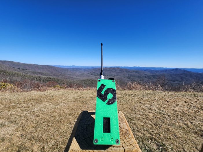
Tag: backpacking

  • Meshtastic: Revolutionizing Off-Grid Communication for Campers and Outdoor Enthusiasts

    Meshtastic: Revolutionizing Off-Grid Communication for Campers and Outdoor Enthusiasts

    For outdoor enthusiasts, reliable communication can be a matter of safety, not just convenience. When venturing into remote areas, traditional communication methods often fail due to lack of cellular coverage. Meshtastic offers an innovative solution to this challenge by providing long-range, off-grid communication that doesn’t rely on cellular networks or internet connectivity. This open-source technology enhances camping and hiking experiences by improving safety, coordination, and peace of mind.

    What is Meshtastic?

    Meshtastic is an open-source, off-grid mesh networking system that leverages LoRa (Long Range) technology to enable communication without cellular infrastructure. Unlike traditional systems, Meshtastic creates a private network of interconnected devices that can send messages, GPS coordinates, and sensor data across significant distances. The project began with a simple goal of keeping hiking buddies connected in the outdoors but has evolved to support various applications, including search and rescue operations and disaster recovery.

    As of 2025, Meshtastic has reached version 2.6, which includes significant enhancements such as a new standalone user interface and improved routing.

    Core Features and Benefits

    Mesh Networking

    Meshtastic devices operate as interconnected nodes in a mesh network. Each device not only sends and receives messages but also relays them to other devices within range. This relay system significantly extends the network’s reach, making it ideal for groups spread across challenging terrain.

    Text Messaging

    The core functionality of Meshtastic is text messaging, allowing users to communicate essential information without requiring heavy equipment or expensive satellite systems. Whether coordinating meeting points or sending emergency alerts, text messaging provides reliable communication in remote settings.

    Location Sharing

    One of Meshtastic’s most valuable features is GPS location sharing, which allows users to track each other’s positions in real-time. This capability is crucial for preventing group members from getting lost and simplifies coordination in unfamiliar terrain.

    Privacy and Security

    Meshtastic prioritizes user privacy, offering end-to-end encryption for all communications. This ensures that messages remain confidential within your group, with no external access to your conversations.

    Long Battery Life

    Unlike smartphones that require frequent charging, Meshtastic devices are designed for energy efficiency. Depending on usage, devices can operate for days or even weeks on a single charge, making them ideal for extended outdoor adventures where power sources are limited.

    Long-Range Coverage

    The LoRa technology powering Meshtastic allows for communication over several miles, depending on terrain and environmental conditions. Open areas like plains provide optimal coverage, while dense forests may reduce the range. However, the mesh network design helps mitigate these limitations by relaying messages through multiple devices.

    Why Campers Love Meshtastic

    Off-Grid Reliability

    In many wilderness locations, cellular networks are either weak or nonexistent. Meshtastic bridges this communication gap by operating completely independent of traditional infrastructure. This means you can stay connected with your group even in the most remote locations.

    For example, hikers in the backcountry of a national park can send messages to group members several miles away, ensuring coordination even when trails diverge.

    Enhanced Safety

    Safety is paramount in outdoor adventures. Meshtastic’s GPS location-sharing ensures that every group member’s whereabouts can be tracked in real-time. In emergencies, like a lost hiker or injury, responders can quickly locate individuals.

    In April 2025, during a massive power outage in Europe, Meshtastic proved invaluable for emergency communications. Users shared real-time updates and advice when cellular networks were down, demonstrating its effectiveness during crises.

    Key safety benefits include:

    • Preventing group members from getting lost
    • Quick alerts if someone is in danger
    • Monitoring children or less experienced hikers

    Affordability

    Traditional off-grid communication solutions like satellite phones can be prohibitively expensive. Meshtastic provides a much more affordable alternative, with compatible devices starting around $30. Additionally, there are no recurring subscription fees, making it an excellent long-term investment.

    For families who camp occasionally, Meshtastic offers cost-efficient safety and connectivity without the financial burden of more expensive systems.

    Ease of Group Coordination

    Large camping groups often face logistical challenges when coordinating activities or planning meeting points. Meshtastic simplifies this by enabling seamless communication among all members, regardless of their distance from each other.

    Common coordination scenarios include:

    • Notifying the group of delays or changes in plans
    • Coordinating rendezvous points during multi-trail hikes
    • Maintaining communication when splitting into smaller groups

    Meshtastic’s flexibility comes from its compatibility with various devices, each offering unique features for different needs. Here’s a comparison of popular options:

    LILYGO T-Beam

    • Pros: Built-in GPS, Wi-Fi and Bluetooth connectivity, affordable
    • Cons: Higher power consumption, larger size
    • Best for: Users needing reliable GPS tracking who don’t mind the larger size

    LILYGO T-Echo

    • Pros: Extremely low power consumption, E-Ink screen for excellent outdoor visibility, includes GPS and protective case
    • Cons: Higher price point, no Wi-Fi
    • Best for: Extended trips where battery life is critical

    Heltec LoRa 32 V3

    • Pros: Compact design, integrated OLED display, affordable and beginner-friendly
    • Cons: No built-in GPS, requires external case for durability
    • Best for: Beginners seeking a simple, lightweight messaging device

    RAK Wireless WisBlock Starter Kit

    • Pros: Modular design for customization, low power consumption, OTA update capabilities
    • Cons: Requires assembly and technical knowledge
    • Best for: Advanced users who want a customizable solution

    SenseCAP T1000-E

    A rugged, waterproof GPS tracker built for off-grid communication. Compact and easy to use, it’s perfect for backcountry travel where cell service doesn’t reach.
    Read the full review on the SenseCAP T1000-E.

    • Pros: Waterproof (IP65-rated), durable design, built-in GPS, compact
    • Cons: No display for viewing messages, limited expandability
    • Best for: Outdoor enthusiasts prioritizing durability in challenging conditions

    When choosing a device, consider your specific needs:

    • Need GPS tracking? Go for the T-Beam or SenseCAP T1000-E
    • Prioritize battery life? Choose the T-Echo
    • Want to customize? The RAK Wireless WisBlock is ideal
    • New to Meshtastic? Start with the Heltec LoRa 32 V3

    Setting Up Your Meshtastic Network

    Setting up a Meshtastic network is straightforward, even for beginners. Here’s a simplified guide:

    1. Choose the Right Hardware

    Select a device that matches your needs, considering factors like GPS capabilities, battery life, and display options.

    2. Install the Meshtastic Firmware

    • Download the latest firmware from the Meshtastic website
    • Use the Web Flasher tool (compatible with Chrome and Edge browsers)
    • Follow the on-screen instructions to flash the firmware to your device

    3. Pair with the Meshtastic App

    • Download the official Meshtastic app for Android or iOS
    • Enable Bluetooth on your phone
    • Open the app and scan for your device
    • Follow the prompts to pair and configure settings

    4. Configure Your Network

    • Set a unique network name
    • Enable encryption for secure communication
    • Adjust power settings to optimize for either battery life or range
    • Conduct a range test in your environment

    5. Add More Devices

    • Repeat the firmware installation and pairing process for each additional device
    • Each new device extends the network’s range and reliability

    Pro Tips

    • Bring backup batteries for extended trips
    • Label multiple devices for easy identification
    • Always test your setup before heading out

    Practical Use Cases

    Group Coordination

    Meshtastic simplifies communication when groups split for different activities. It keeps everyone updated about meeting points and changes in plans, even when teams are miles apart.

    Hiking Safety

    When hiking dense trails, Meshtastic’s GPS tracking ensures no one gets lost. If someone takes a wrong turn, their location remains visible to others in the network, allowing for quick guidance back to the group.

    Family Camping

    For families with children, Meshtastic provides peace of mind. Parents can monitor their kids’ locations around the campsite, allowing them to explore while staying safe.

    Extended Backcountry Adventures

    On multi-day treks in remote areas, Meshtastic keeps groups connected across vast distances without cellular networks. This is particularly valuable when navigating challenging or unfamiliar terrains.

    Emergency Situations

    In emergencies, Meshtastic can be a lifesaver. Users can send SOS messages and coordinate assistance, even in areas with no other communication options.

    Adventure Races and Competitions

    During outdoor competitions, Meshtastic helps track team locations and provides real-time updates for effective strategy coordination.

    Tips for Maximizing Performance

    Use Solar Chargers

    For extended trips, portable solar panels can recharge your Meshtastic devices during the day, ensuring continuous operation without carrying numerous spare batteries.

    Strategic Device Placement

    To maximize range in challenging terrain, place devices in elevated positions. In valleys or dense forests, positioning a relay node at higher elevation can significantly extend coverage.

    Waterproof Your Devices

    Most Meshtastic devices aren’t inherently waterproof. Use waterproof pouches or cases to protect them from rain, snow, and accidental splashes.

    Customize Device Settings

    Adjust settings to match your specific needs:

    • Increase transmission power for longer range
    • Reduce message frequency to conserve battery
    • Find the optimal balance for your environment

    Expand Your Network with Extra Devices

    The strength of a mesh network improves with more nodes. Consider placing extra devices at key locations (like camp or high points) to strengthen the network, even if not everyone carries a device.

    Latest Updates (2025)

    Meshtastic continues to evolve with exciting new features:

    Meshtastic UI (MUI)

    The 2.6 update introduces Meshtastic UI, a new interface for standalone devices that eliminates the need for a phone app. This touchscreen experience makes interacting with your Meshtastic network more intuitive and accessible.

    Next-Hop Routing

    A new routing algorithm for Direct Messages improves message delivery across the network, making communication more reliable in complex environments.

    InkHUD for E-Ink Devices

    The new InkHUD interface provides a heads-up display for e-ink devices, offering real-time network monitoring with minimal power consumption.

    Meshtastic Solutions

    A new initiative called Meshtastic Solutions now supports the open-source project’s growth and long-term success. This venture provides expertise for building tools and systems with Meshtastic, ensuring continued development and high-quality products.

    Closing

    Meshtastic represents a revolutionary approach to off-grid communication for outdoor enthusiasts. By providing reliable, secure, and affordable connectivity in remote areas, it enhances both safety and convenience during camping and hiking adventures.

    Key takeaways include:

    • Independent operation without cellular or internet infrastructure
    • Enhanced safety through GPS tracking and reliable messaging
    • Cost-effective alternative to expensive satellite systems
    • Versatility for various outdoor activities and group sizes

    Whether you’re planning a family camping trip, an extended backcountry adventure, or preparing for emergency scenarios, Meshtastic offers a powerful solution to stay connected where traditional communication fails.

    To learn more about Meshtastic and join the community, visit Meshtastic.org.

  • Linville Gorge: A Hiker’s Haven in North Carolina

    Linville Gorge: A Hiker’s Haven in North Carolina

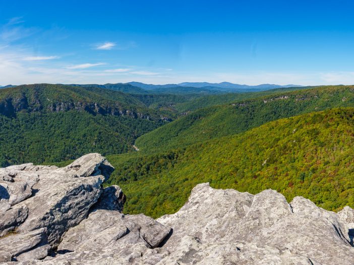
    Nestled within the heart of North Carolina’s Blue Ridge Mountains, Linville Gorge is a hiker’s paradise just waiting to be explored. This magnificent, wild canyon stretches over 12 miles long and is often referred to as the “Grand Canyon of the East.” With its rugged beauty, breathtaking views, and a diverse array of trails, Linville Gorge offers an unforgettable hiking experience for adventurers of all levels.

    How Hard is the Hike to Linville Falls?

    The hike to Linville Falls is relatively accessible for most hikers, offering various trails with different levels of difficulty to suit your preferences and abilities. The easiest and most popular route is the Linville Falls Trail, which is 1.6 miles round trip and considered moderate in difficulty. The trail features several overlooks, providing stunning views of the multi-tiered waterfall. For a more challenging experience, consider taking the Plunge Basin Trail, a 1-mile strenuous hike that descends into the gorge and offers an up-close view of the falls.

    What is the Most Beautiful Gorge in North Carolina?

    While beauty is subjective, many people consider Linville Gorge to be one of the most beautiful gorges in North Carolina, if not the most beautiful. Known as the “Grand Canyon of the East,” Linville Gorge boasts dramatic cliffs, lush forests, and cascading waterfalls that create a breathtaking and diverse landscape. The gorge’s rugged terrain and remote wilderness offer a true escape into nature, providing endless opportunities for adventure and tranquility.

    What is the Hardest Trail in Linville Gorge?

    The most challenging trail in Linville Gorge is arguably the Linville Gorge Trail, also known as the LGT or “The Gorge Trail.” This 11.5-mile trail traverses the base of the gorge and follows the Linville River. The trail is strenuous and technical, with frequent elevation changes, rocky terrain, and several challenging river crossings. Hikers should be well-prepared and experienced before attempting this trail, as it can take several days to complete and requires backcountry navigation skills.

    Is Linville Falls Worth Visiting?

    Absolutely! Linville Falls is not only one of the most famous and photographed waterfalls in North Carolina, but it is also a must-visit destination for nature lovers and outdoor enthusiasts. The falls’ unique, multi-tiered cascade and the surrounding Linville Gorge create a stunning and dramatic landscape that is well worth the effort of hiking to its multiple overlooks. The area offers a variety of trails for all skill levels, ensuring that visitors can find a route that suits their abilities and interests.

    But the Gorge is more than just a pretty place to hike; it’s also home to a unique ecosystem that needs our protection. As you trek through this stunning landscape, you’ll be walking among rare plant species and diverse wildlife, all of which contribute to the area’s delicate balance. It’s crucial that we, as visitors, do our part to respect and preserve the environment, ensuring that Linville Gorge remains a cherished treasure for generations to come.

    So lace up your hiking boots and get ready for an epic adventure as we explore the ins and outs of Linville Gorge, one of North Carolina’s most awe-inspiring natural wonders. In this informal, descriptive, and informative guide, we’ll cover everything you need to know about hiking in Linville Gorge, from trail highlights to practical advice for making your trip both enjoyable and eco-friendly. Let’s dive in!

    Getting to Linville Gorge

    Location and directions

    Linville Gorge, part of the Pisgah National Forest, is located in western North Carolina, approximately 70 miles northeast of Asheville. The main access point for hiking trails in the gorge is the Linville Gorge Information Cabin, where you can find trail maps and helpful information.

    To get there from Asheville, head east on I-40 and take exit 81 for US-221 N towards Linville Falls. Continue on US-221 N for about 29 miles, then turn right onto NC-183. In just under 4 miles, turn left onto Kistler Memorial Highway/NC-1238, and the Information Cabin will be on your left after about 2 miles.

    Nearby towns and facilities

    The towns closest to Linville Gorge are Marion, Morganton, and Boone. Marion and Morganton are located to the southeast, while Boone is situated to the northwest. All three towns offer accommodations, dining options, and grocery stores for stocking up on supplies before your hike.

    Best times to visit

    While Linville Gorge can be visited year-round, the most popular time to hike is during the spring and fall months, when temperatures are mild and the foliage is at its most vibrant. Spring brings a burst of wildflowers, while fall offers a colorful display of changing leaves. Summer can also be a great time to visit, but keep in mind that temperatures can be quite hot and humid, making hiking more strenuous. In the winter, snow and ice can make some trails inaccessible, so be sure to check trail conditions before venturing out during this season.

    Preparing for Your Hike

    Essential gear and clothing

    To ensure a safe and enjoyable hike in Linville Gorge, it’s crucial to pack the right gear. The following items are recommended for your hiking adventure, taking into account the terrain, weather conditions, and types of trails you may encounter:

    • Sturdy hiking boots: Opt for footwear with good ankle support and a grippy sole to navigate the rugged, uneven terrain of the gorge.
    • Weather-appropriate clothing: Dress in layers to adapt to changing temperatures, and pack rain gear for unexpected showers.
    • Navigation tools: Bring a map, compass, and/or GPS device to help you stay on course, as some trails may be less well-marked or maintained.
    • Hydration and nutrition: Carry plenty of water, especially during hot summer months, and pack high-energy snacks or a packed lunch to keep your energy levels up.
    • First-aid kit: Include basic first-aid supplies such as adhesive bandages, pain relievers, antiseptic wipes, and any personal medications you may require.
    • Emergency supplies: Pack a whistle, a signal mirror, and a lightweight emergency blanket in case you need to signal for help or spend an unplanned night in the wilderness.
    • Sun protection: Wear sunscreen, sunglasses, and a hat to protect yourself from the sun’s harmful rays, especially during summer hikes.
    • Insect repellent: Bring bug spray to ward off mosquitoes, ticks, and other insects that can be common in the gorge.
    • Trekking poles (optional): Consider using trekking poles to provide extra support and stability on steep or rocky trails.
    • Camera or smartphone: Capture the stunning landscapes and memorable moments of your Linville Gorge adventure.

    By packing these essential items, you’ll be well-equipped to tackle the challenges and enjoy the rewards of hiking in Linville Gorge, regardless of the trail you choose or the season in which you visit.

    Weather considerations

    Weather in Linville Gorge can be unpredictable, so it’s important to check the forecast before setting out on your hike. In addition to dressing in layers, be prepared for sudden changes in temperature, rain, or even snow at higher elevations during colder months. Start your hikes early in the day to avoid afternoon thunderstorms that are common in the summer months.

    Safety precautions and tips

    It’s important to note that Linville Gorge can be a challenging and sometimes dangerous destination. On average, at least one person per month is rescued from the gorge due to various reasons such as injuries, getting lost, or encountering unexpected hazards. To minimize the risk of accidents and ensure a safe hiking experience, consider the following tips:

    • Stay on marked trails: The terrain in the gorge can be challenging, so it’s crucial to stay on designated trails to avoid getting lost or injured.
    • Know your limits: Choose a trail that matches your experience and fitness level. Don’t hesitate to turn back if you feel uncomfortable or tired.
    • Be aware of wildlife: While encounters with dangerous wildlife are rare, it’s essential to know how to react if you encounter a bear, snake, or other wild animals.
    • Share your plans: Let someone know your hiking plans, including your intended route and expected return time, in case of an emergency.
    • Cell phone reception: Reception can be spotty in the gorge, so don’t rely solely on your phone for communication or navigation.
    • Hike with a buddy: Whenever possible, hike with a partner or a group. This not only makes the journey more enjoyable but also provides an extra level of safety in case of an emergency.
    • Know your route: Familiarize yourself with the trail you plan to hike and any potential hazards it may present. Be aware of the trail’s difficulty level and any technical sections that might require special skills or equipment.
    • Carry emergency supplies: In addition to your essential gear, pack a whistle, a signal mirror, and a lightweight emergency blanket. These items can be invaluable in case you need to signal for help or spend an unplanned night in the wilderness.
    • Stay alert: Pay close attention to your surroundings and be prepared for changing weather conditions, slippery terrain, or any other potential hazards that may arise during your hike.

    By keeping these safety tips in mind, you’ll be better prepared for your Linville Gorge adventure and significantly reduce the risk of accidents or needing rescue. Stay safe and enjoy the spectacular beauty of the gorge!

    Seasonal Considerations: Adapting to Linville Gorge’s Changing Weather

    Linville Gorge’s hiking experience can vary significantly depending on the season, with each offering its unique challenges and highlights. Being aware of these seasonal differences can help you plan and prepare for a safe and enjoyable hike in the gorge.

    Spring: The spring season brings colorful wildflowers and rushing waterfalls as the snow melts, but it can also come with unpredictable weather, including sudden rainstorms and temperature fluctuations. Be prepared for wet and muddy trails, and pack waterproof gear and extra layers to stay comfortable.

    Summer: Summer days can be hot and humid, with the potential for afternoon thunderstorms. Stay hydrated, wear sun protection, and consider starting your hike early in the morning to avoid the heat. Be especially cautious of slippery rocks near waterfalls and stream crossings.

    Fall: Autumn offers cooler temperatures and vibrant foliage, making it a popular time to hike in Linville Gorge. However, the trails can be crowded during peak leaf season, so plan your visit accordingly. Pack extra layers, as temperatures can drop quickly in the evenings.

    Winter: Winter brings snow, ice, and frigid temperatures, making some trails and access points impassable or challenging to navigate. If you choose to hike during this season, be prepared for winter conditions by packing appropriate gear, such as microspikes or snowshoes, and researching trail conditions before setting out.

    By understanding the seasonal variations in Linville Gorge, you can make informed decisions about when to visit and what to expect during your hiking adventure. Always be prepared for changing weather conditions, and adjust your plans as needed to stay safe and enjoy the best that each season has to offer.

    Exploring Linville Gorge’s Natural Beauty

    As you hike through Linville Gorge, you’ll be treated to a diverse array of natural wonders that showcase the beauty of this rugged landscape. From dramatic cliffs and lush forests to cascading waterfalls and panoramic views, there’s no shortage of breathtaking sights to discover.

    Marvel at the dramatic cliffs

    Linville Gorge’s sheer cliffs are one of its most striking features, providing awe-inspiring backdrops for photos and challenging terrain for rock climbers. As you hike along the rim, you’ll find numerous overlooks offering sweeping views of these towering rock faces and the gorge below. It’s important to remember that safety should be a top priority when exploring these areas, as the ledges can be dangerous if not approached with caution.

    When admiring the view or taking photos, always maintain a safe distance from the edge, and be aware of your surroundings. Uneven terrain, loose rocks, or slippery surfaces can pose hazards, especially if you’re not paying attention. If you’re hiking with children, be sure to keep a close eye on them and hold their hands near ledges.

    For rock climbers, proper preparation and adherence to safety guidelines are crucial. Be sure to use appropriate climbing gear, have a solid understanding of the route you plan to take, and only attempt climbs within your skill level. Additionally, it’s wise to climb with a partner or inform someone of your plans before embarking on a climbing adventure.

    By prioritizing safety and being cautious around the ledges in Linville Gorge, you can enjoy the spectacular views and thrilling adventures this park offers while minimizing risks and ensuring a memorable experience.

    Wander through lush forests


    The trails of Linville Gorge wind through dense forests filled with diverse flora, providing a rich and varied backdrop for your hike. As you navigate the gorge, you’ll encounter a lush mix of tree species, including tulip poplars, oaks, hickories, and pines, along with an understory of rhododendron, mountain laurel, and various ferns.

    Tulip poplars, the tallest hardwoods in the eastern United States, can be easily identified by their unique, tulip-shaped leaves and large, greenish-yellow flowers that bloom in late spring. Oaks are another prevalent species in the gorge, distinguished by their lobed leaves and the production of acorns. Hickories are known for their compound leaves and durable wood, which is often used for tool handles and furniture. Pines, with their needle-like leaves and distinct cones, provide year-round greenery to the forest landscape.

    As you hike, take time to appreciate the natural beauty around you, marvel at the towering canopy, and breathe in the fresh, earthy scents of the forest.

    Discover cascading waterfalls

    Linville Gorge is home to several enchanting waterfalls that invite hikers to pause and enjoy the soothing sounds of water tumbling over rocks. Don’t miss Linville Falls, a multi-tiered waterfall that’s easily accessible via a short trail and offers stunning views from multiple overlooks. In addition to Linville Falls, the gorge also features other beautiful cascades worth exploring, such as:

    • Duggers Creek Falls: This small, picturesque waterfall is located near the Linville Falls Visitor Center and is a short walk from the parking area. The gentle cascade is surrounded by lush vegetation, making it a perfect spot for a peaceful break.
    • Babel Tower Falls: For those seeking a more challenging adventure, the Babel Tower Trail leads to a striking waterfall that plunges down the rocky cliffs of Linville Gorge. The strenuous hike rewards visitors with an up-close view of the cascade and the opportunity to explore the base of the waterfall.
    • Cathedral Falls: Accessible via the Pinch-In Trail, Cathedral Falls is another hidden gem in Linville Gorge. The hike to this waterfall can be strenuous, but the dramatic cascade and the serene pool at its base are well worth the effort.

    As you hike through Linville Gorge, take the time to seek out these captivating waterfalls and immerse yourself in the natural beauty they offer. Each cascade provides a unique experience, making every waterfall visit a memorable part of your Linville Gorge adventure.

    Take in panoramic vistas

    Linville Gorge is home to several enchanting waterfalls that invite hikers to pause and enjoy the soothing sounds of water tumbling over rocks. Don’t miss Linville Falls, a multi-tiered waterfall that’s easily accessible via a short trail and offers stunning views from multiple overlooks. In addition to Linville Falls, the gorge also features other beautiful cascades worth exploring, such as:

    • Duggers Creek Falls: This small, picturesque waterfall is located near the Linville Falls Visitor Center and is a short walk from the parking area. The gentle cascade is surrounded by lush vegetation, making it a perfect spot for a peaceful break.
    • Babel Tower Falls: For those seeking a more challenging adventure, the Babel Tower Trail leads to a striking waterfall that plunges down the rocky cliffs of Linville Gorge. The strenuous hike rewards visitors with an up-close view of the cascade and the opportunity to explore the base of the waterfall.
    • Cathedral Falls: Accessible via the Pinch-In Trail, Cathedral Falls is another hidden gem in Linville Gorge. The hike to this waterfall can be strenuous, but the dramatic cascade and the serene pool at its base are well worth the effort.

    As you hike through Linville Gorge, take the time to seek out these captivating waterfalls and immerse yourself in the natural beauty they offer. Each cascade provides a unique experience, making every waterfall visit a memorable part of your Linville Gorge adventure.

    Wildlife Encounters: Meeting the Gorge’s Inhabitants

    While hiking through Linville Gorge, you’ll have the opportunity to spot a variety of wildlife species that call this rugged landscape home. From birds of prey soaring overhead to small mammals scurrying through the underbrush, the gorge’s diverse habitats support a wide range of creatures.

    Some common wildlife you might encounter include:

    • White-tailed deer
    • Black bears
    • Wild turkeys
    • Peregrine falcons
    • River otters
    • Eastern box turtles
    • Various songbirds

    When observing wildlife, it’s important to follow these guidelines to ensure both your safety and the well-being of the animals:

    • Keep a safe distance: Do not approach or attempt to touch wildlife. Use binoculars or a camera with a zoom lens to get a closer look without disturbing the animals.
    • Do not feed wildlife: Feeding animals can alter their natural behavior, making them more likely to approach humans and potentially become aggressive. Additionally, human food can be harmful to their health.
    • Stay quiet and move slowly: Avoid making loud noises or sudden movements that might startle or disturb wildlife.

    By respecting these guidelines, you can enjoy memorable encounters with Linville Gorge’s wildlife while ensuring their continued well-being in this beautiful and wild environment.

    As you explore the gorge, be sure to take in all the unique aspects of its natural beauty. This incredible destination offers endless opportunities for adventure, tranquility, and connection with nature.

    Top Trails to Explore

    Linville Gorge offers a variety of trails for hikers of all levels. Here are some of the top trails that you won’t want to miss:

    Babel Tower Trail: A Steep Challenge with Rewarding Views

    Length: 2.4 miles round trip
    Difficulty: Strenuous

    This steep, challenging hike takes you to the base of Babel Tower, an impressive rock formation with panoramic views of the gorge. The trail begins at the Babel Tower trailhead, where there is limited parking available. The hike starts with a steep descent through a dense forest before reaching the tower, where you can take in the breathtaking scenery and even go for a refreshing dip in the nearby Linville River. Along the way, you’ll find water sources like creeks and designated campsites for an overnight stay.

    Linville Falls Trail: Captivating Waterfalls and Scenic Vistas

    Length: 1.6 miles round trip
    Difficulty: Moderate

    Linville Falls is one of the most iconic sights in the gorge, and this moderate hike takes you to several viewpoints of the stunning cascades. The trail begins at the Linville Falls Visitor Center, where there is ample parking available. The trail meanders through lush forests and offers spectacular views of the falls and the surrounding cliffs. There are water sources along the trail, such as creeks and streams, and a few designated campsites near the Linville Falls area for those wishing to extend their adventure.

    Hawksbill Mountain Trail: A Must-See Panoramic Summit

    Length: 2 miles round trip
    Difficulty: Moderate

    Climbing to the summit of Hawksbill Mountain is a must-do for any Linville Gorge visitor. The trail begins at the Hawksbill Mountain trailhead, where there is limited parking available. This moderately challenging trail takes you through beautiful forests and meadows before reaching the summit, where you’ll be rewarded with 360-degree views of the gorge and surrounding mountains. There are no water sources along this trail, so be sure to bring enough water for your hike. Designated campsites can be found near the summit for those wishing to spend the night.

    Shortoff Mountain Trail: A Hike with Stunning Views and Secluded Camping

    Length: 9.8 miles round trip
    Difficulty: Moderate

    The hike to Shortoff Mountain begins at the Wolf Pit trailhead, where there is a small parking area. The trail follows the eastern rim of Linville Gorge, providing sweeping views of the canyon and surrounding peaks. Along the way, you’ll pass through a mix of forests and rocky outcrops. There are several designated camping spots on the mountain, making this an ideal overnight hike for those looking to get away from it all. However, water sources are scarce, so be prepared to carry enough water for your hike.

    The Pinch-In Trail: The Most Challenging Adventure in the Gorge

    Length: 4 miles round trip
    Difficulty: Strenuous

    For experienced hikers seeking a true challenge, the Pinch-In Trail is a must. This strenuous hike begins at the Kistler Memorial Highway trailhead, where there is limited parking available. The trail takes you from the rim of the gorge down to the Linville River, with steep climbs and rocky terrain throughout. Along the way, you’ll pass by towering cliffs, lush forests, and cascading waterfalls. You’ll find designated campsites along the river, but water sources are limited, so plan accordingly.

    Linville Gorge Grand Loop: A Comprehensive Adventure Through the Best of the Gorge

    Length: 22 miles round trip
    Difficulty: Strenuous

    For experienced hikers seeking an unforgettable, immersive experience, the Linville Gorge Grand Loop is the ultimate trail to tackle. This challenging 23-mile loop takes you through the heart of the gorge, combining the best of several trails, including the Linville Gorge Trail (LGT), the Jonas Ridge Trail, and the Mountains-to-Sea Trail (MST), making it the longest trail in the Linville Gorge Wilderness. You’ll encounter breathtaking views, dramatic cliffs, lush forests, and cascading waterfalls while traversing the gorge’s rim and floor. The Linville Gorge Grand Loop offers an unparalleled adventure for those looking to fully explore this remarkable destination.

    The Grand Loop connects several trails, including the Babel Tower Trail, Pinch-In Trail, Linville Gorge Trail, and the Spence Ridge Trail, among others. This epic hike requires careful planning, as it typically takes 2-3 days to complete and involves navigating difficult terrain and steep elevation changes. There are designated camping spots along the route, making it perfect for a multi-day backpacking trip. Be sure to bring plenty of water, food, and a map or GPS device, as some sections can be remote and challenging to navigate.

    Leave No Trace Principles

    As you explore Linville Gorge, it’s crucial to minimize your impact on the environment and preserve the area’s natural beauty for future generations. Adhering to the Leave No Trace principles is an essential part of being a responsible hiker.

    Importance of respecting the environment

    The gorge’s unique ecosystem is home to diverse flora and fauna that rely on a delicate balance to thrive. By practicing Leave No Trace principles, you can help protect this fragile environment and ensure that future visitors can enjoy the same pristine landscapes that you experience.

    Key principles for responsible hiking

    To minimize your impact while hiking in Linville Gorge, follow these seven Leave No Trace principles:

    • Plan ahead and prepare: Research your hike, check weather conditions, and pack appropriately to minimize the need for resource-intensive improvisations on the trail.
    • Travel and camp on durable surfaces: Stick to established trails and camp in designated sites to prevent damage to vegetation and soil.
    • Dispose of waste properly: Pack out all trash, leftover food, and litter. Use established bathroom facilities when available, or dig a small hole at least 200 feet away from water sources to bury human waste.
    • Leave what you find: Don’t pick plants, remove rocks, or disturb historical or cultural artifacts. Leave the area as you found it for others to enjoy.
    • Minimize campfire impact: Use a camp stove for cooking instead of making a fire, or utilize designated fire rings in established camping areas. Keep fires small and burn only small sticks found on the ground.
    • Respect wildlife: Observe animals from a distance and never feed them. Keep your food secure and store it away from your sleeping area to avoid attracting wildlife.
    • Be considerate of other visitors: Keep noise levels down, yield to other hikers on the trail, and follow posted trail etiquette guidelines.

    How to minimize your impact on the trail

    By adhering to these principles, you can ensure your Linville Gorge adventure is as eco-friendly as possible. Remember, every small action adds up, and together, we can make a significant difference in preserving the pristine beauty of this incredible destination.

    Camping in Linville Gorge

    For those looking to extend their Linville Gorge adventure and sleep under the stars, there are several camping options available in the area. Keep in mind that practicing responsible camping is crucial to protecting the gorge’s delicate ecosystem.

    Designated camping spots

    Several designated camping areas are available within Linville Gorge, with both backcountry and car camping options. Some popular backcountry sites can be found along the Shortoff Mountain Trail and the Linville Gorge Grand Loop. For car camping, the Table Rock Picnic Area and the Linville Falls Campground provide easy access to the gorge’s trail network.

    Obtaining permits and regulations

    If you plan on camping in Linville Gorge between May 1 and October 31, you’ll need a permit for overnight stays in the backcountry. These permits are limited to help preserve the area and can be obtained through the National Forest Service. Permits are not required for car camping at established campgrounds.

    Remember to follow all posted regulations, including fire restrictions and group size limits, to ensure a safe and enjoyable experience for both you and the environment.

    Tips for a safe and eco-friendly camping experience

    To make your Linville Gorge camping trip as safe and environmentally friendly as possible, keep these tips in mind:

    • Choose established campsites: Stick to designated camping areas to minimize your impact on the environment.
    • Store food properly: Use bear-resistant containers or hang food in a tree at least 10 feet off the ground and 4 feet away from the trunk to prevent attracting wildlife.
    • Practice Leave No Trace principles: Follow the Leave No Trace guidelines detailed in the previous section to ensure your camping experience is as low-impact as possible.
    • Be fire smart: Use a camp stove for cooking or utilize designated fire rings, and always fully extinguish fires before leaving your campsite.
    • Prepare for changing weather: Pack appropriate gear for sudden temperature drops or rain, and always be prepared for emergencies.

    By following these guidelines, you can help preserve the natural beauty of Linville Gorge and create lasting memories of your camping adventure.

    Preserving Linville Gorge for Future Generations

    As you venture through the breathtaking landscapes of Linville Gorge, remember that it’s up to all of us to preserve this incredible destination for future generations. By practicing responsible hiking and camping, we can protect the unique qualities that make Linville Gorge such a cherished natural wonder.

    The role of responsible visitors

    As visitors, we play a vital role in maintaining the health and beauty of Linville Gorge. Our actions, both large and small, can have a lasting impact on the environment. By being mindful of our choices and following Leave No Trace principles, we can minimize our impact and contribute to the long-term preservation of this remarkable place.

    Supporting conservation efforts

    In addition to being responsible hikers and campers, we can also support the ongoing conservation efforts in Linville Gorge. Consider donating to or volunteering with organizations dedicated to protecting the area, such as the Linville Gorge Wilderness Area, the Friends of the Linville Gorge, or the Pisgah National Forest. These groups work tirelessly to maintain the trails, monitor wildlife, and implement restoration projects that help protect the gorge’s unique ecosystem.

    Spreading awareness

    Finally, one of the most powerful ways we can help preserve Linville Gorge is by spreading awareness. Share your experiences and knowledge with friends, family, and fellow hikers, encouraging them to adopt responsible practices when exploring the great outdoors. The more people who understand the importance of protecting our natural spaces, the more likely we are to safeguard these precious environments for generations to come.

    Conclusion: Discovering the Magic of Linville Gorge

    Embarking on a hiking adventure in Linville Gorge is an unforgettable experience that allows you to immerse yourself in the rugged beauty of one of North Carolina’s most cherished natural wonders. From the stunning waterfalls and panoramic vistas to the serene backcountry camping spots, Linville Gorge offers a little something for everyone.

    As you explore this incredible destination, remember to practice responsible hiking and camping to minimize your impact on the environment. By adhering to Leave No Trace principles, supporting conservation efforts, and spreading awareness, we can all play a part in preserving Linville Gorge for future generations to enjoy.

    So lace up your hiking boots, pack your backpack, and set off on an adventure that’s sure to be both challenging and rewarding. Happy trails, and may the magic of Linville Gorge stay with you long after you’ve returned home.

    Nearby Attractions and Accommodations: Extending Your Linville Gorge Adventure

    If you’re looking to explore more of the surrounding area or extend your stay near Linville Gorge, there are plenty of nearby attractions and accommodations to consider. From scenic drives to charming mountain towns, you’ll find an array of options for all interests and budgets.

    Nearby Attractions

    • Blue Ridge Parkway: This iconic scenic drive offers stunning views of the Appalachian Mountains and is easily accessible from Linville Gorge. Along the parkway, you’ll find numerous overlooks, hiking trails, and points of interest to explore.
    • Grandfather Mountain: Just a short drive from Linville Gorge, this popular destination features a mile-high swinging bridge, wildlife habitats, and several hiking trails.
    • Boone and Blowing Rock: These charming mountain towns are located within an hour’s drive from Linville Gorge and offer a variety of shopping, dining, and cultural experiences.

    Accommodations

    • Camping: In addition to the backcountry camping options within Linville Gorge, you’ll find several campgrounds nearby, such as the Linville Falls Campground, which offers both tent and RV sites.
    • Cabins and vacation rentals: Rent a cozy mountain cabin or vacation home in the surrounding area to enjoy a comfortable and private retreat during your stay.
    • Hotels and B&Bs: The nearby towns of Boone, Blowing Rock, and Spruce Pine offer a variety of hotels, motels, and bed & breakfasts to suit different budgets and preferences.

    By incorporating these nearby attractions and accommodations into your Linville Gorge itinerary, you can create a more immersive and memorable experience in this beautiful region of North Carolina. Happy exploring!

  • Where to Camp

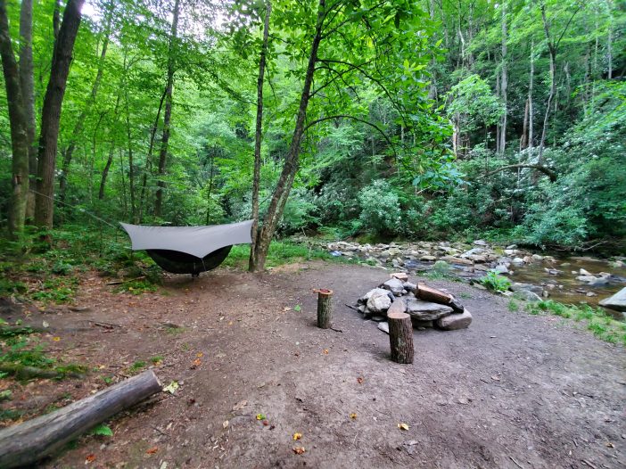
    Ask yourself what expectations, goals, and limits do you have for the outdoor activities you’re planning. Consider the same for everyone that will be joining the group. The trip may be a simple night of KOA car camping or five days of backpacking your local National Forest. Do your research on which wilderness areas are nearby and note what outdoor activities are allowed. Checkup on any fees, laws, policies, or paperwork that may be required. Not all locations will allow overnight parking without a permit. You may have to register your trip into the area with the local Park Service. The National Park Service provides a search engine for locating parks and information about them.


    Shade by the creek

    Car camping allows access to nature for individuals who might not be able to hike long distances such as children and seniors. The sites that are provided for vehicles are usually very near each other however it can vary for each campground. This can be good because it creates a neighborhood feeling where you can walk around meeting people while the kids play among the campsites. The luxuries of electricity, running water, and sewage are also usually provided as well as a level place for RVs, picnic tables, and fire pits.

    Backpacking requires more effort and you may not see other people on your trip however you’ll be visiting beautiful scenery that has a lighter footprint from humans. How much gear you can bring with is limited, so you must choose wisely. The emergency plan will have to take into account the distances needed to hike back to a vehicle or contact help. This may seem daunting but you’ll be rewarded with grand views of pristine wilderness, the peacefulness of nature, and a chance to witness its wildlife.


    Cover from the sun

    When picking the location you’ll want to be aware of what’s around the site that may be a hazard. Look out for dead or damaged branches in trees that could fall on someone. Are there any ledges, steep slopes, or loose rocks? Try to spot any ground hornet or paper wasp nests in the vicinity. Know what people in the group are allergic to and how to spot it. Water can be appealing to camp next to but be aware that temperatures can get low at night. Use the lay of the land to protect the camp from winds and secure tarps to shield against rain and sun.

  • Isolated Lookout in Buffalo Gap, VA


    Starting Up

    You can find Elliott Knob within the George Washington National Forest. It’s one of Virginia’s highest peaks with a wonderful view of the Shenandoah Valley. At this elevation there are species of trees usually found hundreds of miles to the north. Two groves of Red Spruce grow on the summit with dispersed campsites throughout them. This unique location has an old forest fire lookout that’s open to those that can make the hike. Two routes lead to the summit. The easier Falls Hollow Trail that is 8.3 miles or the gravel access that climbs 2,000 ft within 2.5 miles.


    Gravel road to the summit which is closed to public traffic

    The gravel logging road ascends with few switchbacks and does provide a challenge. Even if taking the hiking trail, part of reaching the summit is via the old gravel access.


    Walked past this one with him only retreating to the road edge

    Rabbits, deer, bobcats and black bears live in this lush mountain habitat. I spotted a bear cub before it quickly vanished off into the undergrowth. Oaks and Hickory primarily make up the woods but Maples and Birch trees can be found too. Ferns and Wild raspberry patches can be seen among the rhododendron understory.


    Man made pond near the springs below the summit
    The Falls Hollow Trail
    The final ascent to the top

    There are many trails to explore in the area, some more traveled then others. Technicians accessing the communications equipment at the peak traverse the gravel road daily. These towers and buildings are well labelled with keep out and no trespassing signs. Yet they don’t impose on the view too much and the AC units noise becomes trivial compared to sound of the wind.


    Old fire lookout surrounded by Black Raspberries

    Elliott Knob fire tower

    The view from a decommissioned forest service tower is thrilling. It will not disappoint even on days when visibility doesn’t allow a panoramic view. The clouds coming roweling up the side of the mountain and hit you like a fog bank. At night you can see the surrounding towns, cities and the cars traveling between them. These lights do not impede on the starlight and you can make out the milky way and many constellations. The weather was decent while I was here, moderate cloud cover and at times lifting for a better view.


    On the walkway of the tower
    Inside the lookout

    Within the tower


    The fence for the tower was closed to the public but it seems they gave up on keeping people out and the gate is now open. However there are antennas and cables on the tower in operation, so it’s best to treat these things with respect. It would be a shame to give the forest service a reason to lock it up again. The building atop the tower is in decent shape. A few broken windows and mice that haven taken up residence. You can stay inside the structure, under the tower or one of the many surrounding campsite.


    The walls are covered in messages from past campers

    A location like this is very unique and must be treated similarly to how we tread lightly in nature. We can’t let this spot become damaged from our visits. Please don’t do anything that would damaged this structure, area or yourself. When it comes to safety, know your limits and don’t put yourself into a dangerous spot. We need to be watching out for each other and the environment when hiking and camping. Pack it in, pack it out. And don’t wantonly destroy plants and wildlife. Let’s keep things looking this good for future generations.